Mandi Tehsil
Tehsil in Jammu and Kashmir, India world
Tehsil in Jammu and Kashmir, India
33°47′46″N 74°15′14″E / 33.79611°N 74.25389°E / 33.79611; 74.25389 India
India Jammu and Kashmir
 (2011)
185102
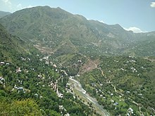
Mandi is a town and a tehsil in the Poonch district of the Indian union territory of Jammu and Kashmir.[1] Mandi is located in east of the Poonch district, about 171 kilometres (106 mi) from Srinagar and 1 kilometre (0.62 mi) south of the Line of Control with Pakistan. The Ancient Hindu temple Baba Budha Amernath is located here.
Demographics
Religion in Mandi Tehsil (2011)[2]
Islam (96.14%)
Hinduism (2.94%)
Sikhism (0.43%)
Christianity (0.15%)
Buddhism (0.01%)
Not Stated (0.34%)
The total projected population of Mandi Tehsil is 77,947, with 41,365 males and 36,582 females according to the 2011 census of India. The population includes Gujjars, Bakerwals, Pahari-Pothwari Speakers,[3] which is intermediate between Lahnda and Punjabi.[4] and Kashmiris.
Transportation
Air
Poonch Airport is a non-operational airstrip in the district headquarters Poonch. The nearest airport to Mandi is Sheikh ul-Alam International Airport in Srinagar, located 180 kilometres from Mandi.
Rail
There is no railway connectivity to Mandi. There are plans to construct a Jammu–Poonch line which will connect Jammu with Poonch with railways. The nearest major railway station is Jammu Tawi railway station located 240 kilometres from Mandi.
Road
The tehsil is connected to other places in Jammu and Kashmir and India by the NH 144A and other intra-district roads.
See also
References
- ^ "Administrative Setup in District Poonch". Poonch District. Retrieved 15 September 2019.
- ^ "Mandi Tehsil Population". Census India. Retrieved 10 July 2021.
- ^ Lothers & Lothers 2010, p. 2.
- ^ Shackle 1979, p. 201.
Works cited
- Lothers, Michael; Lothers, Laura (2010). Pahari and Pothwari: a sociolinguistic survey (Report). SIL Electronic Survey Reports. Vol. 2010–012.
- Shackle, Christopher (1979). "Problems of classification in Pakistan Panjab". Transactions of the Philological Society. 77 (1): 191–210. doi:10.1111/j.1467-968X.1979.tb00857.x. ISSN 0079-1636.
- v
- t
- e
 Union Territory of Jammu and Kashmir
- History of Kashmir
- Kashyapa
- Rajatarangini
- Kambojas
- Lalitaditya Muktapida
- Didda
- Muslim conquests in the Indian subcontinent
- Zayn al-Abidin
- Shah Mir dynasty
- Durrani Empire
- Mughal Empire
- Dogra Empire
- Sikh Empire
- East India Company
- Gulab Singh
- Zorawar Singh
- Jamwal
- Indian Rebellion of 1857
- British Raj
- Kashmir Committee
- Partition of India
- Hari Singh
- Kashmir conflict
- Indo-Pakistani wars and conflicts
- Insurgency
- Darbar Move
- Exodus of Kashmiri Hindus
- Development
and politics
- Reorganisation Act (2019)
- Jammu & Kashmir National Conference
- Jammu and Kashmir Peoples Democratic Party
- All Parties Hurriyat Conference
- Jammu and Kashmir People's Conference
- Instrument of Accession
- Article 370
- Elections in Jammu and Kashmir
- Indira–Sheikh Accord
- Simla Agreement
- Sheikh Abdullah
- Karan Singh
- Prem Nath Dogra
- Bakshi Ghulam Muhammad
- Omar Abdullah
- Jitendra Singh
- Syed Ali Shah Geelani
- Mehbooba Mufti
- Mehr Chand Mahajan
- Mirwaiz Umar Farooq
- Mufti Muhammad Sayeed
- Nirmal Kumar Singh
- Farooq Abdullah
- Ghulam Nabi Azad
- Yasin Malik
- Sajjad Gani Lone
- Shabir Shah
- Public Safety Act, 1978
places
divisions
| Jammu division | |
|---|---|
| Kashmir division |
- Akingam
- Achabal
- Pulwama
- Budgam
- Ganderbal
- Shopian
- Bandipore
- Kulgam
- Downtown
- Nowshera
- Gurez
- Pattan
- Kangan
- Hazratbal
- Awantipora
- Tral
- Qazigund
- Kokernag
- Shangus
- Bijbehara
- Doru
- Pahalgam
- Pattan
- Uri
- Kreeri
- Boniyar
- Tangmarg
- Sopore
- Rafiabad
- Karnah
- Kupwara
- Lolab
- Handwara
- Langate
- Charari Sharief
- Beerwah
- Chadoora
- Bagh e Mehtab
- Sumbal Sonawari
- Quimoh
- Pahloo
- Damhal Hanji Pora
- Soura
- Buchpora
- Jawahar Nagar Srinagar
- Rajbagh
- Bemina
- Maisuma
- Karan Nagar
- Indira Nagar, Srinagar
- Lal Chowk
- Sonwar Bagh
- Nowhatta
- Shalimar Bagh, Srinagar
- Lal Bazar
- Jukura
- Munawar Abad
- Badami Bagh
- Nowshera, Srinagar
- Singhpora
- Magam
- Daksum
- Sinthan top
- Cricket Association
- Cricket team
- Football association
- International Cricket Stadium
- Kashmir International Half Marathon
- Royal Springs Golf Course, Srinagar
- Ladakh Marathon
This article related to a location in Jammu and Kashmir is a stub. You can help Wikipedia by expanding it. |
- v
- t
- e


