Maklavan
City in Gilan province, Iran
City in Gilan, Iran
Maklavan Persian: ماکلوان | |
|---|---|
City | |
 | |
| 37°11′32″N 49°11′35″E / 37.19222°N 49.19306°E / 37.19222; 49.19306[1] | |
| Country | Iran |
| Province | Gilan |
| County | Fuman |
| District | Sardar-e Jangal |
| Population (2016 Census)[2] | |
| • Total | 1,635 |
| Time zone | UTC+3:30 (IRST) |
Maklavan (Persian: ماکلوان)[a] is a city in, and the capital of, Sardar-e Jangal District of Fuman County, in Iran's northwestern Gilan province. It also serves as the administrative center for Sardar-e Jangal Rural District.[4] It is a merger of the former villages of Maklavan-e Bala and Maklavan-e Pain.[5]
Demographics
Population
At the time of the 2006 National Census, Maklavan's population (as the total of the two predecessor villages before their merger) was 1,690 in 442 households.[6] The following census in 2011 counted 1,707 people in 508 households.[7] The 2016 census measured the population as 1,635 people in 536 households,[2] by which time the villages had merged to establish the new city of Maklavan.[5]
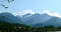
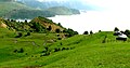
Gallery


See also
 Iran portal
Notes
References
- ^ OpenStreetMap contributors (3 October 2023). "Maklavan, Fuman County" (Map). OpenStreetMap (in Persian). Retrieved 3 October 2023.
- ^ a b "Census of the Islamic Republic of Iran, 1395 (2016)". AMAR (in Persian). The Statistical Center of Iran. p. 01. Archived from the original (Excel) on 4 December 2020. Retrieved 19 December 2022.
- ^ Maklavan can be found at GEOnet Names Server, at this link, by opening the Advanced Search box, entering "-3074349" in the "Unique Feature Id" form, and clicking on "Search Database".
- ^ Mousavi, Mirhossein (2 February 1366). "Creation and formation of ten rural districts including villages, farms and places in Fuman County under Gilan province". Islamic Parliament Research Center (in Persian). Ministry of Interior, Board of Ministers. Archived from the original on 22 August 2012. Retrieved 12 December 2023.
- ^ a b Rahimi, Mohammad Reza (16 March 2013). "Recognition of Maklavan-e Bala village from the functions of Fuman County in Gilan province after merging with Maklavan-e Pain village as Maklavan city". Qavanin (in Persian). Ministry of Interior, Political and Defense Commission. Archived from the original on 3 October 2023. Retrieved 3 October 2023.
- ^ "Census of the Islamic Republic of Iran, 1385 (2006)". AMAR (in Persian). The Statistical Center of Iran. p. 01. Archived from the original (Excel) on 20 September 2011. Retrieved 25 September 2022.
- ^ "Census of the Islamic Republic of Iran, 1390 (2011)". Syracuse University (in Persian). The Statistical Center of Iran. p. 01. Archived from the original (Excel) on 8 October 2023. Retrieved 19 December 2022.
External links
- Aerial Map Maklavan
- v
- t
- e


- Alshaytan Mountain
- Anzali Lagoon
- Astarachay
- Anzali Maritime Museum
- Laton Waterfall
- Astara Cactus museum
- Emarat-i Kulah Farangi Rasht
- Estil Lagoon
- Ghaziayan bridge
- Heyran road
- Heyran Gondola lift
- Rasht Municipality (city hall)
- Roudkhan Castle
- Sajiran waterfall
- Lunak waterfall
- Marlik royal cemetery
- Masouleh
- Moin Mausoleum
- Muhtasham garden
- Kull ancient castle
- Rasht museum
- Sheitankoh
- Tea Museum of Lahijan
- Zahed Gilani's Shrine
- Tea museum
 | This Fuman County location article is a stub. You can help Wikipedia by expanding it. |
- v
- t
- e


