Lunca Cernii de Jos
Commune in Hunedoara, Romania
(2020–2024) (2021-12-01)[1]
337300
Lunca Cernii de Jos (Hungarian: Alsónyiresfalva, German: Birkendorf) is a commune in Hunedoara County, Transylvania, Romania. It is composed of eight villages: Ciumița (Csumicapuszta), Fântâna (Vádtelep), Gura Bordului, Lunca Cernii de Jos, Lunca Cernii de Sus (Felsőnyiresfalva), Meria (Kékesfalva), Negoiu (Nyegojlunka), and Valea Babii.
Geography
The commune is located in the southwestern part of the county. The nearest city is Hunedoara, 46 km (29 mi) distant; the county seta, Deva, is 70 km (43 mi) to the northeast. Lunca Cernii de Jos is situated among the foothills of the Poiana Ruscă Mountains. The average altitude is 850 m (2,790 ft), and the terrain is hilly. The commune borders two other counties, Caraș-Severin and Timiș.[2]
Villages
| Name | Population (2011) | Coordinates |
|---|---|---|
| Ciumița | 0[3] | 45°39′49″N 22°34′44″E / 45.66361°N 22.57889°E / 45.66361; 22.57889 |
| Fântâna | 25[4] | 45°40′10″N 22°35′29″E / 45.66944°N 22.59139°E / 45.66944; 22.59139 |
| Gura Bordului | 58[5] | 45°38′12″N 22°31′56″E / 45.63667°N 22.53222°E / 45.63667; 22.53222 |
| Lunca Cernii de Jos | 157[6] | 45°37′59″N 22°37′0″E / 45.63306°N 22.61667°E / 45.63306; 22.61667 |
| Lunca Cernii de Sus | 229[7] | 45°38′21″N 22°35′3″E / 45.63917°N 22.58417°E / 45.63917; 22.58417 |
| Meria | 246[8] | 45°39′38″N 22°38′1″E / 45.66056°N 22.63361°E / 45.66056; 22.63361 |
| Negoiu | 171[9] | 45°36′39″N 22°33′48″E / 45.61083°N 22.56333°E / 45.61083; 22.56333 |
| Valea Babii | 19[10] | 45°37′27″N 22°34′25″E / 45.62417°N 22.57361°E / 45.62417; 22.57361 |
The name of the commune derives from lunca ("valley") of the Cerna River. Lunca Cernii de Jos and Lunca Cernii de Sus lie for 11 km (6.8 mi) along the river valley; the local peasantry works in animal husbandry and logging. Meria is located on a mountainside at over 1,000 m (3,300 ft) altitude, separated from other villages by high peaks, deep valleys and dense forest. Negoiu is situated in the Negoiului and Sterminosului valleys.[2]
-
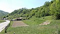 Gura Bordului
 -
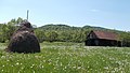 Lunca Cernii de Sus
 -
 Peasant family in Meria (1911)


References
- ^ "Populaţia rezidentă după grupa de vârstă, pe județe și municipii, orașe, comune, la 1 decembrie 2021" (XLS). National Institute of Statistics.
- ^ a b Description at the town hall site[dead link]
- ^ (in Hungarian) Historical census data
- ^ (in Hungarian) Historical census data
- ^ (in Hungarian) Historical census data
- ^ (in Hungarian) Historical census data
- ^ (in Hungarian) Historical census data
- ^ (in Hungarian) Historical census data
- ^ (in Hungarian) Historical census data
- ^ (in Hungarian) Historical census data
- v
- t
- e
Hunedoara County, Romania
- Băcia
- Baia de Criș
- Băița
- Balșa
- Bănița
- Baru
- Bătrâna
- Beriu
- Blăjeni
- Boșorod
- Brănișca
- Bretea Română
- Buceș
- Bucureșci
- Bulzeștii de Sus
- Bunila
- Burjuc
- Cârjiți
- Cerbăl
- Certeju de Sus
- Crișcior
- Densuș
- Dobra
- General Berthelot
- Ghelari
- Gurasada
- Hărău
- Ilia
- Lăpugiu de Jos
- Lelese
- Lunca Cernii de Jos
- Luncoiu de Jos
- Mărtinești
- Orăștioara de Sus
- Pestișu Mic
- Pui
- Răchitova
- Rapoltu Mare
- Râu de Mori
- Ribița
- Romos
- Sălașu de Sus
- Sântămăria-Orlea
- Sarmizegetusa
- Șoimuș
- Teliucu Inferior
- Tomești
- Toplița
- Totești
- Turdaș
- Vălișoara
- Vața de Jos
- Vețel
- Vorța
- Zam
 | This Hunedoara County location article is a stub. You can help Wikipedia by expanding it. |
- v
- t
- e


