Ludington Light
Lighthouse in Michigan, United States
Lighthouse
43°57′13.002″N 86°28′9.737″W / 43.95361167°N 86.46937139°W / 43.95361167; -86.46937139Ludington North Breakwater Light
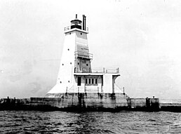
The Ludington Light is a 57-foot (17 m) tall steel-plated lighthouse in Ludington, Michigan, which lies along the eastern shores of Lake Michigan, at the end of the breakwater on the Pere Marquette Harbor. Given its location on the northern breakwater where the Pere Marquette River meets Lake Michigan, it is sometimes known as the Ludington North Breakwater Light. Underlying the building itself is a prow-like structure, which is designed to break waves.
History
The station was established in 1871. This light was first lit in 1924, and it is presently operational. It was automated in 1972. The light is structurally integrated into the steel and reinforced concrete pier upon which it is built. It has a square pyramidal form, and is white with a black lantern. The original lens was a Fourth Order Fresnel lens.[3] On October 17, 1995 the Fresnel lens was removed from the lantern. It was replaced by a 12-inch (300 mm) Tideland Signal ML-300 acrylic optic.[4] The original lens was loaned to Historic White Pine Village where it is displayed as part of their maritime history exhibit.[5]
A fog signal building is integrated into the tower. It originally had a Type F Diaphone signal, and a FA-232 is now in operation. A radio beacon is also in place and operational.[6]
In 2006, the Ludington Breakwater Lighthouse was opened to the public for the first time in its history. The Coast Guard transferred ownership to the City of Ludington under the terms of the National Historic Lighthouse Preservation Act. The lighthouse is being operated and maintained in partnership with the Sable Points Lighthouse Keepers Association,[7] which is a volunteer group that maintains, restores and operates this light, the Big Sable Point Lighthouse and the Little Sable Point Lighthouse.[8]
The lighthouse is open to the public during the summer season for climbing tours.
See also
References
- ^ Light List, Volume VII, Great Lakes (PDF). Light List. United States Coast Guard.
- ^ "National Register Information System". National Register of Historic Places. National Park Service. 2009-03-13. Archived from the original on 2008-07-25. Retrieved 2010-08-03.
- ^ "Historic Light Station Information and Photography: Michigan". United States Coast Guard Historian's Office. Archived from the original on 2017-05-01.
- ^ "Seeing The Light - The 300mm plastic lighthouse optic". Retrieved 1 August 2016.
- ^ "Seeing The Light - Ludington North Pierhead Lighthouse". Retrieved 1 August 2016.
- ^ "Ludington North Pier Lighthouse, MI". Retrieved 1 August 2016.
- ^ Lighthouse depot newsletter Archived 2007-12-17 at the Wayback Machine
- ^ "Big Sable Point Lighthouse - Ludington Mi -". Archived from the original on 2008-06-15. Retrieved 2008-06-11.
Further reading
- Bibliography on Michigan lighthouses.
- Crompton, Samuel Willard & Michael J. Rhein, The Ultimate Book of Lighthouses (2002) ISBN 1-59223-102-0; ISBN 978-1-59223-102-7.
- Hyde, Charles K., and Ann and John Mahan. The Northern Lights: Lighthouses of the Upper Great Lakes. Detroit: Wayne State University Press, 1995. ISBN 0-8143-2554-8 ISBN 9780814325544.
- Jones, Ray & Bruce Roberts, American Lighthouses (Globe Pequot, September 1, 1998, 1st Ed.) ISBN 0-7627-0324-5; ISBN 978-0-7627-0324-1.
- Jones, Ray,The Lighthouse Encyclopedia, The Definitive Reference (Globe Pequot, January 1, 2004, 1st ed.) ISBN 0-7627-2735-7; ISBN 978-0-7627-2735-3.
- Noble, Dennis, Lighthouses & Keepers: U. S. Lighthouse Service and Its Legacy (Annapolis: U. S. Naval Institute Press, 1997). ISBN 1-55750-638-8; ISBN 978-1-55750-638-2.
- Oleszewski, Wes, Great Lakes Lighthouses, American and Canadian: A Comprehensive Directory/Guide to Great Lakes Lighthouses, (Gwinn, Michigan: Avery Color Studios, Inc., 1998) ISBN 0-932212-98-0.
- Penrod, John, Lighthouses of Michigan, (Berrien Center, Michigan: Penrod/Hiawatha, 1998) ISBN 978-0-942618-78-5 ISBN 9781893624238.
- Pepper, Terry. "Seeing the Light: Lighthouses on the western Great Lakes".
- Putnam, George R., Lighthouses and Lightships of the United States, (Boston: Houghton Mifflin Co., 1933).
- United States Coast Guard, Aids to Navigation, (Washington, DC: U. S. Government Printing Office, 1945).
- Price, Scott T. "U. S. Coast Guard Aids to Navigation: A Historical Bibliography". United States Coast Guard Historian's Office.
- Wagner, John L. "Beacons Shining in the Night: The Lighthouses of Michigan". Clarke Historical Library, Central Michigan University.
- Wagner, John L., Michigan Lighthouses: An Aerial Photographic Perspective, (East Lansing, Michigan: John L. Wagner, 1998) ISBN 1-880311-01-1 ISBN 9781880311011.
- Wargin, Ed, Legends of Light: A Michigan Lighthouse Portfolio (Ann Arbor Media Group, 2006). ISBN 978-1-58726-251-7.
- Wright, Larry and Wright, Patricia, Great Lakes Lighthouses Encyclopedia Hardback (Erin: Boston Mills Press, 2006) ISBN 1-55046-399-3
- v
- t
- e
- Au Sable
- Big Bay Point
- Copper Harbor
- Copper Harbor Front Range
- Crisp Point
- Eagle Harbor
- Eagle Harbor Range Lights
- Eagle River
- Fourteen Mile Point
- Grand Island East Channel
- Grand Island Harbor Rear Range
- Grand Island North
- Grand Marais Range Lights
- Granite Island
- Gull Rock
- Huron Island
- Isle Royale
- Manitou Island
- Marquette Breakwater Outer
- Marquette Harbor
- Mendota (Bete Grise)
- Munising Front Range
- Munising Rear Range
- Ontonagon
- Ontonagon Harbor West Breakwater
- Portage River (Jacobsville)
- Passage Island
- Presque Isle Harbor Breakwater Light
- Rock Harbor
- Rock of Ages
- Sand Hills
- Sand Point Light (Baraga)
- St. Martin Island
- Stannard Rock
- Thunder Bay Island
- Whitefish Point

- Frying Pan Island
- Pipe Island
- Point Iroquois
- Round Island Light (St. Mary's River)
- Six Mile Point Range Rear
- Winter Point Range Front
- Keweenaw Waterway Lower Entrance
- Keweenaw Waterway Upper Entrance
- Portage Lake
- Rouleau Point Range Front and Rear Lights
- Beaver Island Harbor
- Beaver Island Head
- Big Sable Point
- Cedar River
- Charlevoix
- Charlevoix South Pier
- Frankfort
- Frankfort South Range
- Grand Haven North Pierhead
- Grand Haven South Pierhead Entrance
- Grand Haven South Pierhead Inner
- Grand Traverse
- Grays Reef
- Holland Harbor
- Ile Aux Galets
- Little Sable Point
- Little Traverse
- Ludington
- Manistee Pierhead
- Manning Memorial
- Mission Point
- Mission Point (1933)
- Muskegon Breakwater
- Muskegon Pier
- North Manitou Shoal
- Pentwater North Pierhead
- Pentwater South Pierhead
- Point Betsie
- Portage Lake
- South Fox Island
- South Haven
- South Manitou Island
- St. Joseph North Pier Inner
- St. Joseph North Pier Outer
- Waugoshance
- White River
- White Shoal
- Alpena
- Caseville Harbor
- Charity Island
- Cheboygan Crib
- Cheboygan River Front Range
- Detroit River
- Fort Gratiot
- Forty Mile Point
- Fourteen Foot Shoal
- Gibraltar
- Gravelly Shoal
- Harbor Beach
- Lake St. Clair
- Mariners Memorial
- Middle Island
- Miller Memorial
- New Presque Isle
- Old Presque Isle
- Peche Island Rear Range
- Poe Reef
- Pointe aux Barques
- Port Austin
- Port Sanilac
- Saginaw Bay
- Saginaw River Rear Range
- Spectacle Reef
- St. Clair Flats Front and Rear Range Light
- Sturgeon Point
- Tawas Point
- Thunder Bay Island
- Tri-Centennial Light of Detroit
- William Livingstone Memorial
- Windmill Point
- Au Sable North Pierhead
- Belle Isle
- Clinton River
- Ecorse
- Ecorse Range Rear
- Gibraltar
- Grassy Island
- Grassy Island North Channel Range Lights
- Grassy Island South Channel Range Lights
- Grosse Ile North Channel Range Lights
- Grosse Ile South Channel Range Lights
- Harwood Point East Range Front
- Kalamazoo River
- Mama Juda
- Mama Juda Range Front
- Manistee Main
- Middle Lake George
- Monroe Pier
- New Buffalo
- North Manitou Island
- Saginaw Bay
- Sand Beach North Entrance East
- Squaw Point
- St. Mary's River Lower Range Front
- Vidal Shoals Channel Range Front and Rear Lights
- Windmill Point Range Front and Rear Lights
- Lightship Huron
- List of lifesaving stations in Michigan
- Wixom Lake, Musselman Island lighthouse
| |
|---|---|
| Topics | |
| Lists by state |
|
| Lists by insular areas | |
| Lists by associated state | |
| Other areas | |
| Related | |
| |


| Authority control databases: Geographic |
|
|---|


