List of national monuments in County Carlow
Map all coordinates using OpenStreetMap
Download coordinates as:
- KML
- GPX (all coordinates)
- GPX (primary coordinates)
- GPX (secondary coordinates)
The Irish state has officially approved the following list of national monuments in County Carlow. In the Republic of Ireland, a structure or site may be deemed to be a "national monument", and therefore worthy of state protection, if it is of national importance. If the land adjoining the monument is essential to protect it, this land may also be protected.
National Monuments
| NM# | Monument name | Description | Image | Townland | Location |
|---|---|---|---|---|---|
| 347 | Aghade Holed Stone (Cloghaphoill) | Holed Stone | Aghade | 52°46′12″N 6°44′48″W / 52.770101°N 6.746804°W / 52.770101; -6.746804 | |
| 351 | Ballyloughan Castle | Castle |  | Ballyloughan | 52°40′23″N 6°53′53″W / 52.672957°N 6.898062°W / 52.672957; -6.898062 |
| 486 | Ballymoon Castle | Castle |  | Ballymoon | 52°42′00″N 6°54′25″W / 52.7°N 6.907°W / 52.7; -6.907 |
| 566 | Baunogenasraid | Burial Mound (Cist) | Baunogenasraid | 52°48′45″N 6°49′25″W / 52.812425°N 6.823668°W / 52.812425; -6.823668 | |
| 306 | Carlow Castle | Castle |  | Carlow | 52°50′11″N 6°56′09″W / 52.836389°N 6.935833°W / 52.836389; -6.935833 |
| 545 | Castlemore Moat | Motte and Bailey & Cross Slab | 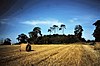 | Castlemore | 52°48′34″N 6°46′21″W / 52.809489°N 6.772553°W / 52.809489; -6.772553 |
| 613 | Browneshill | Portal Tomb | 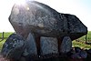 | Kernanstown | 52°50′14″N 6°52′52″W / 52.837337°N 6.881004°W / 52.837337; -6.881004 |
| 393 | Killoughternane Church | Church | 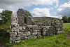 | Killoughternane | 52°38′02″N 6°51′13″W / 52.6339°N 6.8536°W / 52.6339; -6.8536 |
| 603 | Rathvilly Moat | Burial Mound or Motte[1] |  | Knockroe | 52°52′50″N 6°40′42″W / 52.880559°N 6.678207°W / 52.880559; -6.678207 |
| 438 | Leighlinbridge Castle | Castle |  | Leighlinbridge | 52°44′09″N 6°58′41″W / 52.7357°N 6.9781°W / 52.7357; -6.9781 |
| 350 | Lorum High Cross | Cross Fragment |  | Lorum | 52°39′51″N 6°55′56″W / 52.664028°N 6.932335°W / 52.664028; -6.932335 |
| 352 | Nurney Cross | Cross |  | Nurney | 52°45′06″N 6°54′44″W / 52.7518°N 6.9123°W / 52.7518; -6.9123 |
| 3 | St. Mullin's | Early Medieval Ecclesiastical Site |  | St Mullin's | 52°29′20″N 6°55′42″W / 52.488908°N 6.928461°W / 52.488908; -6.928461 |
| 452 | Straboe Grave Slab | Medieval Grave Slab | Straboe | 52°51′41″N 6°46′19″W / 52.861279°N 6.771970°W / 52.861279; -6.771970 |
Sources
- National Monuments in County Carlow
See also
References
- ^ http://webgis.archaeology.ie/historicenvironment/ SMR:CW004-014----


