List of listed buildings in Kilmacolm, Inverclyde
This is a list of listed buildings in the parish of Kilmacolm in Inverclyde, Scotland.
Map all coordinates using OpenStreetMap
Download coordinates as:
- KML
- GPX (all coordinates)
- GPX (primary coordinates)
- GPX (secondary coordinates)
List
| Name | Location | Date Listed | Grid Ref. [note 1] | Geo-coordinates | Notes | LB Number [note 2] | Image |
|---|---|---|---|---|---|---|---|
| Finlaystone House, Port Glasgow Road, By Langbank | 55°55′43″N 4°37′09″W / 55.928627°N 4.619233°W / 55.928627; -4.619233 (Finlaystone House, Port Glasgow Road, By Langbank) | Category A | 13641 |  Upload another image | |||
| Balrossie With Annex, Ornamental Outbuilding, Ancillary Building, Terraces, Steps, Gatepiers, Gates And Railings | 55°53′16″N 4°39′10″W / 55.88772°N 4.652845°W / 55.88772; -4.652845 (Balrossie With Annex, Ornamental Outbuilding, Ancillary Building, Terraces, Steps, Gatepiers, Gates And Railings) | Category B | 49972 |  Upload Photo | |||
| Bridge Of Weir, 28 Quarrier's Village, (Sabbath School Home) | 55°52′03″N 4°37′11″W / 55.867397°N 4.619728°W / 55.867397; -4.619728 (Bridge Of Weir, 28 Quarrier's Village, (Sabbath School Home)) | Category C(S) | 50588 | 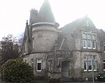 Upload another image | |||
| Bridge Of Weir Hospital Main Block Including Chapel | 55°51′48″N 4°36′48″W / 55.863354°N 4.613318°W / 55.863354; -4.613318 (Bridge Of Weir Hospital Main Block Including Chapel) | Category B | 13232 | Upload Photo | |||
| "Overton", Glen Road, Kilmacolm | 55°53′46″N 4°37′03″W / 55.896226°N 4.617432°W / 55.896226; -4.617432 ("Overton", Glen Road, Kilmacolm) | Category C(S) | 12457 | Upload Photo | |||
| Duchal House, Strathgryfe, By Kilmacolm | 55°52′37″N 4°38′01″W / 55.877043°N 4.633569°W / 55.877043; -4.633569 (Duchal House, Strathgryfe, By Kilmacolm) | Category A | 12463 | Upload Photo | |||
| Bridge Of Weir, 17 Quarrier's Village, 'Alan Dick Home' | 55°52′04″N 4°37′03″W / 55.867892°N 4.617587°W / 55.867892; -4.617587 (Bridge Of Weir, 17 Quarrier's Village, 'Alan Dick Home') | Category C(S) | 50584 | Upload Photo | |||
| Bridge Of Weir, 34 Quarrier's Village, (Glenfarg) | 55°52′03″N 4°36′45″W / 55.867382°N 4.612406°W / 55.867382; -4.612406 (Bridge Of Weir, 34 Quarrier's Village, (Glenfarg)) | Category C(S) | 50586 | Upload Photo | |||
| Kilmacolm Cemetery, Headstone For James Reid | 55°54′06″N 4°38′03″W / 55.901605°N 4.63413°W / 55.901605; -4.63413 (Kilmacolm Cemetery, Headstone For James Reid) | Category B | 51677 | Upload Photo | |||
| Kilmacolm Parish Church ("Old Kirk"), Main Street, Kilmacolm | 55°53′42″N 4°37′37″W / 55.894947°N 4.62688°W / 55.894947; -4.62688 (Kilmacolm Parish Church ("Old Kirk"), Main Street, Kilmacolm) | Category B | 12447 | 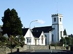 Upload another image | |||
| Kidston Hall, Port Glasgow Road, Kilmacolm | 55°53′43″N 4°37′38″W / 55.895299°N 4.627208°W / 55.895299; -4.627208 (Kidston Hall, Port Glasgow Road, Kilmacolm) | Category C(S) | 12458 |  Upload another image | |||
| Knockbuckle Road, Shallott, St Columba's Junior School With Terrace, Statue, Boundary Wall, Gatepiers And Gates | 55°53′32″N 4°38′09″W / 55.892337°N 4.635853°W / 55.892337; -4.635853 (Knockbuckle Road, Shallott, St Columba's Junior School With Terrace, Statue, Boundary Wall, Gatepiers And Gates) | Category B | 50020 | Upload Photo | |||
| Quarrier's Village, Faith Avenue, Homelea | 55°52′00″N 4°36′59″W / 55.866616°N 4.616303°W / 55.866616; -4.616303 (Quarrier's Village, Faith Avenue, Homelea) | Category C(S) | 50021 | Upload Photo | |||
| The Cross And Lochwinnoch Road, Old Primary School With Boundary Wall | 55°53′37″N 4°37′38″W / 55.893655°N 4.627193°W / 55.893655; -4.627193 (The Cross And Lochwinnoch Road, Old Primary School With Boundary Wall) | Category C(S) | 50022 |  Upload another image | |||
| Bridge Of Weir, 45 Quarrier's Village, (Bethesda') | 55°52′00″N 4°37′02″W / 55.866783°N 4.617337°W / 55.866783; -4.617337 (Bridge Of Weir, 45 Quarrier's Village, (Bethesda')) | Category C(S) | 50585 | Upload Photo | |||
| Bridge Of Weir, 14 Quarrier's Village, 'Overtoun' | 55°52′02″N 4°37′08″W / 55.867281°N 4.618841°W / 55.867281; -4.618841 (Bridge Of Weir, 14 Quarrier's Village, 'Overtoun') | Category C(S) | 50587 | Upload Photo | |||
| Bridge Of Weir, 48 Quarrier's Village, The Marcus Humphrey House (Former Elise Hospital) | 55°52′04″N 4°37′15″W / 55.867884°N 4.620928°W / 55.867884; -4.620928 (Bridge Of Weir, 48 Quarrier's Village, The Marcus Humphrey House (Former Elise Hospital)) | Category C(S) | 50589 | Upload Photo | |||
| "Windyhill", Rowantreehill Road Kilmacolm | 55°53′24″N 4°37′13″W / 55.890078°N 4.620409°W / 55.890078; -4.620409 ("Windyhill", Rowantreehill Road Kilmacolm) | Category A | 12450 | 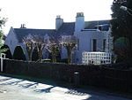 Upload another image | |||
| Quarrier's Village, Mount Zion Church, Including Cemetery And Boundary Walls | 55°52′07″N 4°37′04″W / 55.868578°N 4.617873°W / 55.868578; -4.617873 (Quarrier's Village, Mount Zion Church, Including Cemetery And Boundary Walls) | Category B | 48940 | 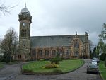 Upload another image | |||
| St. Columba's (Formerly St. James's) Church Of Scotland Duchal Road, Kilmacolm | 55°53′35″N 4°37′37″W / 55.892949°N 4.626969°W / 55.892949; -4.626969 (St. Columba's (Formerly St. James's) Church Of Scotland Duchal Road, Kilmacolm) | Category A | 12448 | Upload Photo | |||
| "Rowantreehill", Rowantreehill Road, Kilmacolm | 55°53′26″N 4°37′15″W / 55.890592°N 4.620748°W / 55.890592; -4.620748 ("Rowantreehill", Rowantreehill Road, Kilmacolm) | Category B | 12449 | Upload Photo | |||
| "Hazelhope", Gryffe Road, Kilmacolm | 55°53′13″N 4°37′24″W / 55.886825°N 4.623324°W / 55.886825; -4.623324 ("Hazelhope", Gryffe Road, Kilmacolm) | Category C(S) | 12454 | Upload Photo | |||
| Lodge Of Auchenbothie House, Port Glasgow Road, By Kilmacolm | 55°54′00″N 4°38′16″W / 55.900008°N 4.637749°W / 55.900008; -4.637749 (Lodge Of Auchenbothie House, Port Glasgow Road, By Kilmacolm) | Category B | 12461 | Upload Photo | |||
| Stable Block With Coachman's Cottage, Etc., At Duchal House | 55°52′37″N 4°38′06″W / 55.877067°N 4.634929°W / 55.877067; -4.634929 (Stable Block With Coachman's Cottage, Etc., At Duchal House) | Category B | 12464 | Upload Photo | |||
| Hope Lodge, ( Originally Lodge To Bridge Of Weir Hospital) | 55°51′47″N 4°36′23″W / 55.863044°N 4.606297°W / 55.863044; -4.606297 (Hope Lodge, ( Originally Lodge To Bridge Of Weir Hospital)) | Category B | 13230 | Upload Photo | |||
| "Greystones", Houston Road, Kilmacolm | 55°53′13″N 4°37′01″W / 55.886862°N 4.616962°W / 55.886862; -4.616962 ("Greystones", Houston Road, Kilmacolm) | Category B | 12453 | Upload Photo | |||
| "Nether Knockbuckle", Knockbuckle, Kilmacolm | 55°53′33″N 4°38′44″W / 55.892454°N 4.645474°W / 55.892454; -4.645474 ("Nether Knockbuckle", Knockbuckle, Kilmacolm) | Category B | 12456 | Upload Photo | |||
| Auchenbothie House, (Former Old Folks Home), Port Glasgow Road, By Kilmacolm | 55°54′12″N 4°38′27″W / 55.903305°N 4.640757°W / 55.903305; -4.640757 (Auchenbothie House, (Former Old Folks Home), Port Glasgow Road, By Kilmacolm) | Category B | 12460 | 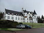 Upload another image | |||
| "Cloak", (Formerly "Mosside"), Cloak Road, By Kilmacolm | 55°54′46″N 4°38′12″W / 55.912722°N 4.636725°W / 55.912722; -4.636725 ("Cloak", (Formerly "Mosside"), Cloak Road, By Kilmacolm) | Category B | 12462 | Upload Photo | |||
| Former R.C. "Bishop's House", (Formerly "Miyanoshta") Porterfield Road, Kilmacolm | 55°53′20″N 4°37′12″W / 55.888927°N 4.619996°W / 55.888927; -4.619996 (Former R.C. "Bishop's House", (Formerly "Miyanoshta") Porterfield Road, Kilmacolm) | Category B | 12451 |  Upload another image | |||
| Craigbet, By Torr Road, Bridge Of Weir | 55°51′51″N 4°36′23″W / 55.864115°N 4.606256°W / 55.864115; -4.606256 (Craigbet, By Torr Road, Bridge Of Weir) | Category B | 13047 | Upload Photo | |||
| "Knapps House", Houston Road, Kilmacolm | 55°53′12″N 4°36′47″W / 55.886666°N 4.613062°W / 55.886666; -4.613062 ("Knapps House", Houston Road, Kilmacolm) | Category B | 12452 | Upload Photo | |||
| "Den O' Gryffe", Knockbuckle Road, Kilmacolm | 55°53′35″N 4°38′51″W / 55.893022°N 4.647496°W / 55.893022; -4.647496 ("Den O' Gryffe", Knockbuckle Road, Kilmacolm) | Category B | 12455 | Upload Photo | |||
| "Water Yetts", Finlaystone Road, Kilmacolm | 55°54′00″N 4°37′40″W / 55.899882°N 4.627694°W / 55.899882; -4.627694 ("Water Yetts", Finlaystone Road, Kilmacolm) | Category B | 12459 | Upload Photo | |||
| Glencairn Road, Old Church Manse | 55°53′34″N 4°37′20″W / 55.892681°N 4.622248°W / 55.892681; -4.622248 (Glencairn Road, Old Church Manse) | Category C(S) | 50019 | Upload Photo |
Key
The scheme for classifying buildings in Scotland is:
- Category A: "buildings of national or international importance, either architectural or historic; or fine, little-altered examples of some particular period, style or building type."[1]
- Category B: "buildings of regional or more than local importance; or major examples of some particular period, style or building type, which may have been altered."[1]
- Category C: "buildings of local importance; lesser examples of any period, style, or building type, as originally constructed or moderately altered; and simple traditional buildings which group well with other listed buildings."[1]
In March 2016 there were 47,288 listed buildings in Scotland. Of these, 8% were Category A, and 50% were Category B, with the remaining 42% being Category C.[2]
See also
Notes
- ^ Sometimes known as OSGB36, the grid reference (where provided) is based on the British national grid reference system used by the Ordnance Survey.
• "Guide to National Grid". Ordnance Survey. Retrieved 12 December 2007.
• "Get-a-map". Ordnance Survey. Retrieved 17 December 2007. - ^ Historic Environment Scotland assign a unique alphanumeric identifier to each designated site in Scotland, for listed buildings this always begins with "LB", for example "LB12345".
References
- All entries, addresses and coordinates are based on data from Historic Scotland. This data falls under the Open Government Licence
- ^ a b c "What is Listing?". Historic Environment Scotland. Retrieved 29 May 2018.
- ^ Scotland's Historic Environment Audit 2016 (PDF). Historic Environment Scotland and the Built Environment Forum Scotland. pp. 15–16. Retrieved 29 May 2018.
- v
- t
- e
- All in Category A
- Gourock
- Greenock
- Inverkip
- Kilmacolm
- Port Glasgow


