List of lighthouses in Wisconsin
Map all coordinates using OpenStreetMap
Download coordinates as:
- KML
- GPX (all coordinates)
- GPX (primary coordinates)
- GPX (secondary coordinates)
This is a list of all lighthouses in the U.S. state of Wisconsin as identified by the United States Coast Guard and other historical sources.
If not otherwise noted, focal height and coordinates are taken from the United States Coast Guard Light List,[1] while location and dates of activation, automation, and deactivation are taken from the United States Coast Guard Historical information site for lighthouses.[2]
| Name | Image | Location | Coordinates | Year first lit | Automated | Year deactivated | Current Lens | Focal Height |
|---|---|---|---|---|---|---|---|---|
| Algoma Pierhead Light | 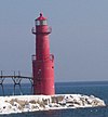 | Algoma | 44°36′25″N 87°25′45″W / 44.6070°N 87.4293°W / 44.6070; -87.4293 (Algoma Pierhead Light) | 1932 | 1973 | Active | Plastic | 048 48 ft (15 m) |
| Ashland Harbor Breakwater Light |  | Ashland | 46°37′42″N 90°52′14″W / 46.6282°N 90.8706°W / 46.6282; -90.8706 (Ashland Harbor Breakwater Light) | 1915 | 1962 | Active | 250mm | 060 60 ft (18 m) |
| Asylum Light |  | Oshkosh | 44°03′44″N 88°30′53″W / 44.062361°N 88.514639°W / 44.062361; -88.514639 | Never Lit | N/A | N/A | None | Unknown |
| Baileys Harbor Light |  | Baileys Harbor | 45°03′21″N 87°05′49″W / 45.0559°N 87.0970°W / 45.0559; -87.0970 (Baileys Harbor Light)[3] | 1853 | Never | 1869 (Now a private home) | None | 054 54 ft (16 m)[4] |
| Baileys Harbor Range Front Light |  | Baileys Harbor | 45°04′13″N 87°07′11″W / 45.0704°N 87.1198°W / 45.0704; -87.1198 (Baileys Harbor Range Front Light)[5] | 1870 | 1930 | Active (Inactive: 1969-2015) | LED | 021 21 ft (6.4 m)[4] |
| Baileys Harbor Range Rear Light |  | Baileys Harbor | 45°04′22″N 87°07′16″W / 45.0729°N 87.121°W / 45.0729; -87.121 (Baileys Harbor Range Rear Light)[6] | 1870 | 1930 | Active (Inactive: 1969-2015) | LED | 036 36 ft (11 m)[4] |
| Calumet Light |  | Calumet | 43°54′54″N 88°19′56.5″W / 43.91500°N 88.332361°W / 43.91500; -88.332361 | 1936 | Never | Active | Unknown | Unknown |
| Cana Island Light |  | Baileys Harbor | 45°05′17″N 87°02′51″W / 45.0881°N 87.0476°W / 45.0881; -87.0476 (Cana Island Light) | 1870 | 1945 | Active | Third-Order Fresnel | 083 83 ft (25 m) |
| Chambers Island Light |  | Gibraltar (Chambers Island) | 45°12′08″N 87°21′53″W / 45.2022°N 87.3648°W / 45.2022; -87.3648 (Chambers Island Light)[7] | 1868 | 1955 | 1961 | None | 068 68 ft (21 m)[7] |
| Chequamegon Point Light |  | Apostle Islands (Long Island) | 46°43′43″N 90°48′33″W / 46.7285°N 90.8093°W / 46.7285; -90.8093 (Chambers Island Light) | 1896[8] | 1964 | 1987 | None | 042 42 ft (13 m)[8] |
| Devils Island Light |  | Apostle Islands (Devils Island) | 47°04′46″N 90°43′41″W / 47.0795°N 90.7281°W / 47.0795; -90.7281 (Devils Island Light) | 1891 (Former) 1901 (Current) | 1978 | Active | Third-order Fresnel | 100 100 ft (30 m) |
| Dunlap Reef Range Lights | Sturgeon Bay | N/A | 1881 | Never | 1924 (The rear range light is now a private home) | None | 018 18 ft (5.5 m) (Front Range) 039 39 ft (12 m) (Rear Range) | |
| Eagle Bluff Light |  | Ephraim | 45°10′07″N 87°14′12″W / 45.1687°N 87.2367°W / 45.1687; -87.2367 (Eagle Bluff Light) | 1868 | 1926 | Active | LED Fifth-Order Fresnel Inactive in tower | 075 75 ft (23 m) |
| Fond du Lac Light |  | Fond du Lac | 43°47′51.54″N 88°26′14.09″W / 43.7976500°N 88.4372472°W / 43.7976500; -88.4372472 | 1933 | Never | Active | Unknown | Unknown |
| Grassy Island Range Lights |  | Green Bay | 44°33′36″N 87°59′35″W / 44.560°N 87.993°W / 44.560; -87.993 (Grassy Island Range Lights (original))[9] (Original) 44°32′10″N 88°00′19″W / 44.5362°N 88.0052°W / 44.5362; -88.0052 (Grassy Island Range Lights (current))[10] (Current) | 1872 | 1934 | 1966 | Sixth-Order Fresnel (Replicas) | 035 35 ft (11 m)[4] (Upper light) 27 ft (8.2 m)[4] (Lower light) |
| Green Bay Harbor Entrance Light |  | Green Bay | 44°39′11″N 87°54′05″W / 44.6531°N 87.9013°W / 44.6531; -87.9013 (Green Bay Harbor Entrance Light) | 1935 | 1979 | Active | Unknown | 072 72 ft (22 m) |
| Green Island Light |  | Peshtigo (Green Island) | 45°03′23″N 87°29′34″W / 45.0564°N 87.4929°W / 45.0564; -87.4929 (Green Island Light)[11] | 1863 | 1933 | 1956 (Now in ruins) | None | 055 55 ft (17 m)[11] |
| Gull Island Light | Apostle Islands (Gull Island) | 46°54′24″N 90°26′36″W / 46.9067°N 90.4433°W / 46.9067; -90.4433 (Gull Island Light) | 1929 | Always | Active | 250mm | 056 56 ft (17 m) | |
| Kenosha Light (Orig: Kenosha North Pierhead Light) | 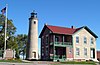 | Kenosha | 42°35′22″N 87°48′57″W / 42.5894°N 87.8157°W / 42.5894; -87.8157 (Kenosha Light)[12] | 1840 (Former) 1867 (Current) | 1996 (Relit) | Active (Inactive: 1906-1996) | Replica | 050 50 ft (15 m)[4] |
| Kenosha North Pier Light |  | Kenosha | 42°35′20″N 87°48′31″W / 42.5888°N 87.8086°W / 42.5888; -87.8086 (Kenosha North Pier Light) | 1848 (Former) 1906 (Current) | 1925 | Active | Fourth-order Fresnel | 050 50 ft (15 m) |
| Kevich Light | 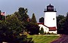 | Grafton | 43°19′24″N 87°53′19″W / 43.3233°N 87.8885°W / 43.3233; -87.8885 (Kevich Light) | 1981 | Always | Active | Halide lamps | 163 163 ft (50 m) |
| Kewaunee Pierhead Light |  | Kewaunee | 44°27′27″N 87°29′34″W / 44.4574°N 87.4929°W / 44.4574; -87.4929 (Kewaunee Pierhead Light) | 1889 (Former) 1931 (Current) | 1981 | Active | Vega-44 LED | 045 45 ft (14 m) |
| La Pointe Light | 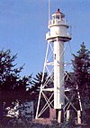 | Apostle Islands (Long Island) | 46°43′43″N 90°47′06″W / 46.7287°N 90.7849°W / 46.7287; -90.7849 (La Pointe Light) | 1858 (Former) 1896 (Current) | 1964 | Active | 300mm | 070 70 ft (21 m) |
| Long Tail Point Light (First) | Green Bay | 44°35′45″N 87°59′01″W / 44.5959°N 87.9835°W / 44.5959; -87.9835 (Long Tail Point Light)[13] | 1848 | Never | 1859 (Now in ruins) | None | 056 56 ft (17 m) | |
| Long Tail Point Light (Second) | Green Bay | N/A | 1859 | Never | 1899 (Destroyed in 1936) | None | Unknown | |
| Long Tail Point Light (Third) | 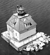 | Green Bay | N/A | 1899 | 1936 | 1973 (Destroyed) | None | Unknown |
| Manitowoc Breakwater Light |  | Manitowoc | 44°05′34″N 87°38′37″W / 44.0928°N 87.6436°W / 44.0928; -87.6436 (Manitowoc Breakwater Light) | 1839 (Former) 1918 (Current) | 1971 | Active | Unknown | 052 52 ft (16 m) |
| Michigan Island Light (New) |  | Apostle Islands (Michigan Island) | 46°52′17″N 90°29′50″W / 46.8714°N 90.4971°W / 46.8714; -90.4971 (Michigan Island Light) | 1929 | 1943 | Active | LED | 170 170 ft (52 m) |
| Michigan Island Light (Old) |  | Apostle Islands (Michigan Island) | N/A | 1857 | Never | 1929 (Replaced) | None | Unknown |
| Milwaukee Breakwater Light |  | Milwaukee | 43°01′37″N 87°52′55″W / 43.0269°N 87.8819°W / 43.0269; -87.8819 (Milwaukee Breakwater Light) | 1899 (Former) 1926 (Current) | 1966 | Active | Unknown | 061 61 ft (19 m) |
| Milwaukee Pierhead Light |  | Milwaukee | 43°01′33″N 87°53′43″W / 43.0259°N 87.8953°W / 43.0259; -87.8953 (Milwaukee Pierhead Light) | 1872 | 1939 | Active | Unknown | 048 48 ft (15 m) |
| Neenah Light (aka:Kimberly Point Lighthouse) | 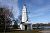 | Neenah | N/A | 1945 | Always | Active | Unknown | Unknown |
| North Point Light | 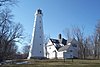 | Milwaukee | 43°03′56″N 87°52′17″W / 43.0656°N 87.8714°W / 43.0656; -87.8714 (North Point Light)[14] | 1855 (Former) 1888 (Current) | 1943 | 1994 | None | 154 154 ft (47 m)[14] |
| Outer Island Light | 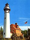 | Apostle Islands (Outer Island) | 47°04′35″N 90°25′00″W / 47.0765°N 90.4167°W / 47.0765; -90.4167 (Outer Island Light) | 1874 | 1961 | Active | VRB-25 | 130 130 ft (40 m) |
| Peshtigo Reef Light |  | Green Bay (Offshore) | 44°57′24″N 87°34′45″W / 44.9566°N 87.5791°W / 44.9566; -87.5791 (Peshtigo Reef Light) | 1936 | Always | Active | Unknown | 072 72 ft (22 m) |
| Pilot Island Light |  | Gills Rock | 45°17′03″N 86°55′11″W / 45.2842°N 86.9197°W / 45.2842; -86.9197 (Pilot Island Light) | 1858 | 1962 | Active | LED | 048 48 ft (15 m) |
| Plum Island Range Front Light |  | Plum Island | 45°18′14″N 86°57′18″W / 45.3038°N 86.9550°W / 45.3038; -86.9550 (Plum Island Range Front Light) (Current location) | 1897 | Never | 1964 | None | 032 32 ft (9.8 m)[4] |
| Plum Island Range Rear Light |  | Plum Island | 45°18′27″N 86°57′30″W / 45.3076°N 86.9582°W / 45.3076; -86.9582 (Plum Island Range Rear Light) | 1897 | 1969 | Active | LED | 084 84 ft (26 m) |
| Port Washington Light |  | Port Washington | 43°23′28″N 87°52′04″W / 43.391°N 87.8677°W / 43.391; -87.8677 (Port Washington Light)[15] | 1849 (Former) 1860 (Current) | Never | 1903 (Now a museum) | Fourth-order Fresnel (Replica) | 113 133 ft (41 m)[16] |
| Port Washington Breakwater Light |  | Port Washington | 43°23′07″N 87°51′35″W / 43.3853°N 87.8597°W / 43.3853; -87.8597[17] | 1889 (Former) 1935 (Current) | 1976 | Active | Unknown | 078 78 ft (24 m) |
| Pottawatomie Light | 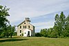 | Rock Island | 45°25′39″N 86°49′44″W / 45.4276°N 86.8288°W / 45.4276; -86.8288 (Pottawatomie Light) | 1836 (Former) 1858 (Current) | 1946 | 1988 | Fourth-order Fresnel (Replica) | 159 159 ft (48 m) |
| Racine Harbor Light |  | Racine | 42°44′03″N 87°46′42″W / 42.7341°N 87.7783°W / 42.7341; -87.7783 (Racine Harbor Light)[18] | 1839 (Former) 1901 (Current) | Never | 1901 | None | 075 75 ft (23 m) |
| Racine North Breakwater Light | Racine | 42°44′05″N 87°46′19″W / 42.7346°N 87.7720°W / 42.7346; -87.7720 (Racine North Breakwater Light)[19] | 1872 (Former) 1904 (Current) | Unknown | 1987[19] | None | 053 53 ft (16 m)[20] | |
| Racine Reef Light | 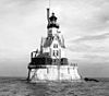 | Racine | 42°43′39″N 87°44′10″W / 42.7276°N 87.7361°W / 42.7276; -87.7361 (Racine Reef Light) | 1899 (Former) 1906 (Current) | 1954 | 1961 | None | 072 72 ft (22 m)[4] |
| Raspberry Island Light |  | Apostle Islands (Raspberry Island) | 46°58′14″N 90°48′18″W / 46.9706°N 90.8050°W / 46.9706; -90.8050 (Raspberry Island Light)[21] | 1862 | 1947 | 1957 (Now a museum) | None | 077 77 ft (23 m)[22] |
| Rawley Point Light |  | Two Rivers | 44°12′39″N 87°30′32″W / 44.2108°N 87.5088°W / 44.2108; -87.5088 (Rawley Point Light) | 1874 (Former) 1894 (Current) | 1979 | Active | Optic | 113 113 ft (34 m) |
| Rockwell Light (aka: Bray's Point Light) |  | Oshkosh | N/A | 1910 | Unknown | 1965 (Estimated) | None | 026 26 ft (7.9 m) |
| Sand Island Light | 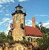 | Apostle Islands (Sand Island) | 47°00′12″N 90°56′15″W / 47.0033°N 90.9374°W / 47.0033; -90.9374 (Sand Island Light) | 1881 | 1921 | Active (Inactive: 1933-1985) | LED | 060 60 ft (18 m) |
| Sheboygan Lighthouse |  | Sheboygan | 43°44′58″N 87°41′34″W / 43.7495°N 87.6927°W / 43.7495; -87.6927 (Sheboygan Breakwater Light) | 1839 (Former) 1915 (Current) | Unknown | Active | Unknown | 055 55 ft (17 m) |
| Sherwood Point Light | 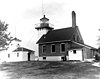 | Nasewaupee (Idlewild) | 44°53′34″N 87°26′00″W / 44.8928°N 87.4334°W / 44.8928; -87.4334 (Sherwood Point Light) | 1883 | 1983 | Active | LED | 061 61 ft (19 m) |
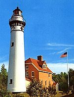
| Sturgeon Bay Canal Light |  | Sturgeon Bay | 44°47′42″N 87°18′48″W / 44.7950°N 87.3133°W / 44.7950; -87.3133 (Sturgeon Bay Canal Light) | 1899 | 1972 | Active | Third-Order Fresnel Lens (Rotating) | 107 107 ft (33 m) |
| Sturgeon Bay Canal North Pierhead Light | 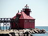 | Sturgeon Bay | 44°47′31″N 87°18′34″W / 44.7920°N 87.3095°W / 44.7920; -87.3095 (Sturgeon Bay Canal North Pierhead Light) | 1882 (Former) 1903 (Current) | 1972 | Active | 300mm | 040 40 ft (12 m) |
| Superior Entry Breakwater Light (aka: Wisconsin Point Light) |  | Superior | 46°42′37″N 92°00′22″W / 46.7102°N 92.0062°W / 46.7102; -92.0062 (Wisconsin Point Light) | 1913 | 1970 | Active | DCB-224 | 070 70 ft (21 m) |
| Two Rivers Light |  | Two Rivers | 44°08′34″N 87°33′38″W / 44.1428°N 87.5605°W / 44.1428; -87.5605 (Two Rivers Light (original)) (Original) 44°09′12″N 87°33′45″W / 44.1532°N 87.5624°W / 44.1532; -87.5624 (Two Rivers Light (current))[23] (Current) | 1886 | Never | 1969 (Now a museum) | None | 035 35 ft (11 m)[24] |
| Wind Point Light | 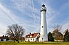 | Racine (Wind Point) | 42°46′52″N 87°45′30″W / 42.7811°N 87.7583°W / 42.7811; -87.7583 (Wind Point Light) | 1880 | 1964 | Active | VRB-25 | 111 111 ft (34 m) |
References
- ^ Light List, Volume VII, Great Lakes (PDF). Light List. United States Coast Guard. 2012.
- ^ "Historic Light Station Information and Photography: Wisconsin". United States Coast Guard Historian's Office. Archived from the original on 2017-05-01.
- ^ "Baileys Harbor Lighthouse". LighthouseFriends. Archived from the original on 2014-03-31. Retrieved 2014-02-26.
- ^ a b c d e f g h Pepper, Terry. "Focal Heights". Archived from the original on 2008-08-30. Retrieved 2014-02-26.
- ^ "Baleys Harbor Range Lights". LighthouseFriends. Retrieved 2014-02-27.
- ^ Light List: Great Lakes, United States and Canada. Government Printing Office. 1925. p. 220. Retrieved 2014-02-27.
baileys harbor front.
- ^ a b "Chambers Island Light". LighthouseFriends. Retrieved 2014-02-24.
- ^ a b Pepper, Terry. "Chequamegon Point Light". Retrieved 2014-02-24.
- ^ Light List: Great Lakes: United States and Canada. Washington, DC: Government Printing Office. 1924. p. 230. Retrieved 2015-02-08.
- ^ "Grassy Island Rage, WI". LighthouseFriends. Retrieved 2015-02-06.
- ^ a b "Green Island Light". LighthouseFriends. Retrieved 2014-02-24.
- ^ "Kenosha Lighthouse". LighthouseFriends. Retrieved 2014-02-26.
- ^ "Long Tail Point, WI". LighthouseFriends. Archived from the original on 2010-09-14. Retrieved 2011-01-07.
- ^ a b "North Point Light". LighthouseFriends. Retrieved 2014-02-24.
- ^ Anderson, Kraig. "Port Washington, WI". LighthouseFriends. Retrieved 2014-02-24.
- ^ Pepper, Terry. "Port Washington Main Lighthouse". Retrieved 2014-02-24.
- ^ "Port Washington Breakwater, WI". LighthouseFriends. Retrieved 2011-01-18.
- ^ "Racine Harbor, WI". LighthouseFriends. Retrieved 2015-01-26.
- ^ a b "Racine Breakwater, WI". LighthouseFriends. Retrieved 2014-03-04.
- ^ Racine Harbor (nautical chart). 1:10,000. NOAA. 1984. Archived from the original on 2017-10-01. Retrieved 2014-03-04.
- ^ "Raspberry Island Light". LighthouseFriends. Retrieved 2014-02-25.
- ^ Pepper, Terry. "Raspberry Island Lighthouse". Retrieved 2014-02-25.
- ^ "Two Rivers Lighthouse". Lighthouse Friends. Archived from the original on 2012-01-24. Retrieved 2012-02-15.
- ^ Pepper, Terry. "Focal Heights". Retrieved 2015-10-02.
- v
- t
- e
- Alabama
- Alaska
- California
- Connecticut
- Delaware
- Florida
- Georgia
- Hawaii
- Illinois and Indiana
- Louisiana
- Maine
- Maryland
- Massachusetts
- Michigan
- Minnesota
- Mississippi
- Nebraska
- New Hampshire
- New Jersey
- New York
- North Carolina
- Ohio
- Oregon
- Pennsylvania
- Rhode Island
- South Carolina
- Texas
- Vermont
- Virginia
- Washington
- Wisconsin
Lighthouses of Wisconsin | ||
|---|---|---|
| Lake Superior |
|  |
| Lake Michigan |
| |
| Lake Winnebago | ||
| Historical (lost) lights |
| |


