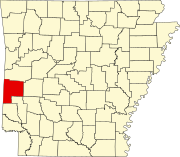
List of lakes of Polk County, Arkansas
Map all coordinates using OpenStreetMap
Download coordinates as:
- KML
- GPX (all coordinates)
- GPX (primary coordinates)
- GPX (secondary coordinates)
There are at least 23 named lakes and reservoirs in Polk County, Arkansas.
Lakes
- Shady Lake, 34°21′42″N 094°01′41″W / 34.36167°N 94.02806°W / 34.36167; -94.02806 (Shady Lake), el. 1,106 feet (337 m) [1]
Reservoirs
- Aeration Lake, 34°14′00″N 094°20′13″W / 34.23333°N 94.33694°W / 34.23333; -94.33694 (Aeration Lake), el. 906 feet (276 m) [2]
- Bethesda Lake, 34°31′55″N 094°14′22″W / 34.53194°N 94.23944°W / 34.53194; -94.23944 (Bethesda Lake), el. 1,207 feet (368 m) [3]
- Polk County, 34°32′54″N 094°17′37″W / 34.54833°N 94.29361°W / 34.54833; -94.29361 (Blue Lake), el. 1,014 feet (309 m) [4]
- Brewer Lake, 34°17′48″N 094°19′07″W / 34.29667°N 94.31861°W / 34.29667; -94.31861 (Brewer Lake), el. 942 feet (287 m) [5]
- City of Mena Sewage Logoon, 34°33′43″N 094°11′02″W / 34.56194°N 94.18389°W / 34.56194; -94.18389 (City of Mena Sewage Logoon), el. 1,014 feet (309 m) [6]
- Cox Lake, 34°34′16″N 094°14′34″W / 34.57111°N 94.24278°W / 34.57111; -94.24278 (Cox Lake), el. 1,109 feet (338 m) [7]
- Dairy Lake, 34°35′30″N 094°05′56″W / 34.59167°N 94.09889°W / 34.59167; -94.09889 (Dairy Lake), el. 919 feet (280 m) [8]
- Faulkner Lake, 34°34′49″N 093°59′31″W / 34.58028°N 93.99194°W / 34.58028; -93.99194 (Faulkner Lake), el. 866 feet (264 m) [9]
- Forbis Lake, 34°36′00″N 094°06′03″W / 34.60000°N 94.10083°W / 34.60000; -94.10083 (Forbis Lake), el. 951 feet (290 m) [10]
- Hillcrest Lake, 34°36′12″N 094°12′07″W / 34.60333°N 94.20194°W / 34.60333; -94.20194 (Hillcrest Lake), el. 1,063 feet (324 m) [11]
- Irons Fork Reservoir, 34°38′52″N 094°07′18″W / 34.64778°N 94.12167°W / 34.64778; -94.12167 (Irons Fork Reservoir), el. 1,083 feet (330 m) [12]
- Ivey Lake, 34°34′30″N 094°24′01″W / 34.57500°N 94.40028°W / 34.57500; -94.40028 (Ivey Lake), el. 958 feet (292 m) [13]
- J and B Lake, 34°33′47″N 094°01′21″W / 34.56306°N 94.02250°W / 34.56306; -94.02250 (J and B Lake), el. 856 feet (261 m) [14]
- Jenkins Lake, 34°19′36″N 094°22′19″W / 34.32667°N 94.37194°W / 34.32667; -94.37194 (Jenkins Lake), el. 1,037 feet (316 m) [15]
- Lake Wilhelmina, 34°36′16″N 094°21′19″W / 34.60444°N 94.35528°W / 34.60444; -94.35528 (Lake Wilhelmina), el. 997 feet (304 m) [16]
- Mena Lake, 34°35′00″N 094°11′54″W / 34.58333°N 94.19833°W / 34.58333; -94.19833 (Mena Lake), el. 1,020 feet (310 m) [17]
- Multipurpose Site One Reservoir, 34°38′52″N 094°07′18″W / 34.64778°N 94.12167°W / 34.64778; -94.12167 (Multipurpose Site One Reservoir), el. 1,083 feet (330 m) [18]
- Patchett Lake, 34°31′46″N 094°09′15″W / 34.52944°N 94.15417°W / 34.52944; -94.15417 (Patchett Lake), el. 1,037 feet (316 m) [19]
- Powell Lake, 34°31′54″N 094°09′53″W / 34.53167°N 94.16472°W / 34.53167; -94.16472 (Powell Lake), el. 1,030 feet (310 m) [20]
- Reeds Lake, 34°37′42″N 094°27′15″W / 34.62833°N 94.45417°W / 34.62833; -94.45417 (Reeds Lake), el. 1,099 feet (335 m) [21]
- Shady Lake, 34°21′30″N 094°01′43″W / 34.35833°N 94.02861°W / 34.35833; -94.02861 (Shady Lake), el. 1,093 feet (333 m) [22]
- Ward Lake, 34°36′28″N 094°14′48″W / 34.60778°N 94.24667°W / 34.60778; -94.24667 (Ward Lake), el. 1,411 feet (430 m) [23]
See also
Notes
- ^ "Shady Lake". Geographic Names Information System. United States Geological Survey, United States Department of the Interior.
- ^ "Aeration Lake". Geographic Names Information System. United States Geological Survey, United States Department of the Interior.
- ^ "Bethesda Lake". Geographic Names Information System. United States Geological Survey, United States Department of the Interior.
- ^ "Blue Lake". Geographic Names Information System. United States Geological Survey, United States Department of the Interior.
- ^ "Brewer Lake". Geographic Names Information System. United States Geological Survey, United States Department of the Interior.
- ^ "City of Mena Sewage Logoon". Geographic Names Information System. United States Geological Survey, United States Department of the Interior.
- ^ "Cox Lake". Geographic Names Information System. United States Geological Survey, United States Department of the Interior.
- ^ "Dairy Lake". Geographic Names Information System. United States Geological Survey, United States Department of the Interior.
- ^ "Faulkner Lake". Geographic Names Information System. United States Geological Survey, United States Department of the Interior.
- ^ "Forbis Lake". Geographic Names Information System. United States Geological Survey, United States Department of the Interior.
- ^ "Hillcrest Lake". Geographic Names Information System. United States Geological Survey, United States Department of the Interior.
- ^ "Irons Fork Reservoir". Geographic Names Information System. United States Geological Survey, United States Department of the Interior.
- ^ "Ivey Lake". Geographic Names Information System. United States Geological Survey, United States Department of the Interior.
- ^ "J and B Lake". Geographic Names Information System. United States Geological Survey, United States Department of the Interior.
- ^ "Jenkins Lake". Geographic Names Information System. United States Geological Survey, United States Department of the Interior.
- ^ "Lake Wilhelmina". Geographic Names Information System. United States Geological Survey, United States Department of the Interior.
- ^ "Mena Lake". Geographic Names Information System. United States Geological Survey, United States Department of the Interior.
- ^ "Multipurpose Site One Reservoir". Geographic Names Information System. United States Geological Survey, United States Department of the Interior.
- ^ "Patchett Lake". Geographic Names Information System. United States Geological Survey, United States Department of the Interior.
- ^ "Powell Lake". Geographic Names Information System. United States Geological Survey, United States Department of the Interior.
- ^ "Reeds Lake". Geographic Names Information System. United States Geological Survey, United States Department of the Interior.
- ^ "Shady Lake". Geographic Names Information System. United States Geological Survey, United States Department of the Interior.
- ^ "Ward Lake". Geographic Names Information System. United States Geological Survey, United States Department of the Interior.