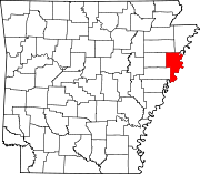
List of lakes of Crittenden County, Arkansas
Map all coordinates using OpenStreetMap
Download coordinates as:
- KML
- GPX (all coordinates)
- GPX (primary coordinates)
- GPX (secondary coordinates)
There are at least 41 named lakes and reservoirs in Crittenden County, Arkansas.
Lakes

- Beautiful Lake, 35°21′24″N 090°26′41″W / 35.35667°N 90.44472°W / 35.35667; -90.44472 (Beautiful Lake), el. 203 feet (62 m) [1]
- Benwood Lake, 35°17′41″N 090°18′27″W / 35.29472°N 90.30750°W / 35.29472; -90.30750 (Benwood Lake), el. 213 feet (65 m) [2]
- Big Lake, 35°21′14″N 090°25′11″W / 35.35389°N 90.41972°W / 35.35389; -90.41972 (Big Lake), el. 203 feet (62 m) [3]
- Blackfish Lake, 35°07′20″N 090°27′08″W / 35.12222°N 90.45222°W / 35.12222; -90.45222 (Blackfish Lake), el. 184 feet (56 m) [4]
- Blue Lake, 35°01′15″N 090°19′13″W / 35.02083°N 90.32028°W / 35.02083; -90.32028 (Blue Lake), el. 194 feet (59 m) [5]
- Brougham Lake, 35°18′07″N 090°24′31″W / 35.30194°N 90.40861°W / 35.30194; -90.40861 (Brougham Lake), el. 200 feet (61 m) [6]
- Buck Lake, 35°11′56″N 090°25′21″W / 35.19889°N 90.42250°W / 35.19889; -90.42250 (Buck Lake), el. 200 feet (61 m) [7]
- Bushy Lake, 34°53′45″N 090°20′47″W / 34.89583°N 90.34639°W / 34.89583; -90.34639 (Bushy Lake), el. 194 feet (59 m) [8]
- Cane Lake, 35°17′51″N 090°29′22″W / 35.29750°N 90.48944°W / 35.29750; -90.48944 (Cane Lake), el. 203 feet (62 m) [9]
- Copperas Lake, 35°03′56″N 090°17′06″W / 35.06556°N 90.28500°W / 35.06556; -90.28500 (Copperas Lake), el. 200 feet (61 m) [10]
- Danner Lake, 35°18′40″N 090°08′58″W / 35.31111°N 90.14944°W / 35.31111; -90.14944 (Danner Lake), el. 210 feet (64 m) [11]
- Dead Timber Lake, 35°26′38″N 090°17′39″W / 35.44389°N 90.29417°W / 35.44389; -90.29417 (Dead Timber Lake), el. 217 feet (66 m) [12]
- Fletcher Lake, 35°05′32″N 090°12′03″W / 35.09222°N 90.20083°W / 35.09222; -90.20083 (Fletcher Lake), el. 203 feet (62 m) [13]
- Goose Lake, 34°54′24″N 090°20′09″W / 34.90667°N 90.33583°W / 34.90667; -90.33583 (Goose Lake), el. 190 feet (58 m) [14]
- Grassy Lake, 35°04′02″N 090°12′33″W / 35.06722°N 90.20917°W / 35.06722; -90.20917 (Grassy Lake), el. 207 feet (63 m) [15]
- Holden Lake, 35°14′20″N 090°25′38″W / 35.23889°N 90.42722°W / 35.23889; -90.42722 (Holden Lake), el. 203 feet (62 m) [16]
- Hood Lake, 35°20′53″N 090°27′05″W / 35.34806°N 90.45139°W / 35.34806; -90.45139 (Hood Lake), el. 203 feet (62 m) [17]
- Hopefield Chute, 35°10′03″N 090°05′39″W / 35.16750°N 90.09417°W / 35.16750; -90.09417 (Hopefield Chute), el. 203 feet (62 m) [18]
- Hopefield Lake, 35°08′24″N 090°04′45″W / 35.14000°N 90.07917°W / 35.14000; -90.07917 (Hopefield Lake), el. 207 feet (63 m) [19]
- Horseshoe Lake, 34°56′01″N 090°20′37″W / 34.93361°N 90.34361°W / 34.93361; -90.34361 (Horseshoe Lake), el. 190 feet (58 m) [20]
- Island Forty Chute, 35°15′38″N 090°09′23″W / 35.26056°N 90.15639°W / 35.26056; -90.15639 (Island Forty Chute), el. 207 feet (63 m) [21]
- Lake David, 35°23′30″N 090°16′06″W / 35.39167°N 90.26833°W / 35.39167; -90.26833 (Lake David), el. 223 feet (68 m) [22]
- Lake Deloche, 34°55′19″N 090°17′22″W / 34.92194°N 90.28944°W / 34.92194; -90.28944 (Lake Deloche), el. 200 feet (61 m) [23]
- Lewis Lake, 35°19′35″N 090°27′31″W / 35.32639°N 90.45861°W / 35.32639; -90.45861 (Lewis Lake), el. 210 feet (64 m) [24]
- Little Grassy Lake, 35°21′06″N 090°25′52″W / 35.35167°N 90.43111°W / 35.35167; -90.43111 (Little Grassy Lake), el. 203 feet (62 m) [25]
- Long Pond, 35°03′42″N 090°15′50″W / 35.06167°N 90.26389°W / 35.06167; -90.26389 (Long Pond), el. 200 feet (61 m) [26]
- Marion Lake, 35°11′54″N 090°09′36″W / 35.19833°N 90.16000°W / 35.19833; -90.16000 (Marion Lake), el. 207 feet (63 m) [27]
- McCarter Lake, 35°12′21″N 090°08′11″W / 35.20583°N 90.13639°W / 35.20583; -90.13639 (McCarter Lake), el. 213 feet (65 m) [28]
- Meneshea Lake, 35°25′40″N 090°12′23″W / 35.42778°N 90.20639°W / 35.42778; -90.20639 (Meneshea Lake), el. 217 feet (66 m) [29]
- Mound City Chute, 35°10′58″N 090°07′00″W / 35.18278°N 90.11667°W / 35.18278; -90.11667 (Mound City Chute), el. 207 feet (63 m) [30]
- North Lake, 35°24′13″N 090°06′37″W / 35.40361°N 90.11028°W / 35.40361; -90.11028 (North Lake), el. 213 feet (65 m) [31]
- Old River Lake, 34°50′42″N 090°19′09″W / 34.84500°N 90.31917°W / 34.84500; -90.31917 (Old River Lake), el. 190 feet (58 m) [32]
- Porter Lake, 34°53′03″N 090°20′04″W / 34.88417°N 90.33444°W / 34.88417; -90.33444 (Porter Lake), el. 190 feet (58 m) [33]
- Shell Lake, 35°08′23″N 090°29′41″W / 35.13972°N 90.49472°W / 35.13972; -90.49472 (Shell Lake), el. 197 feet (60 m) [34]
- South Lake, 35°21′05″N 090°06′47″W / 35.35139°N 90.11306°W / 35.35139; -90.11306 (South Lake), el. 213 feet (65 m) [35]
- Stave Lake, 35°26′15″N 090°11′28″W / 35.43750°N 90.19111°W / 35.43750; -90.19111 (Stave Lake), el. 217 feet (66 m) [36]
- Stump Lake, 35°22′10″N 090°26′06″W / 35.36944°N 90.43500°W / 35.36944; -90.43500 (Stump Lake), el. 207 feet (63 m) [37]
- Swan Lake, 35°03′06″N 090°15′12″W / 35.05167°N 90.25333°W / 35.05167; -90.25333 (Swan Lake), el. 203 feet (62 m) [38]
- Wapanocca Lake, 35°20′43″N 090°14′03″W / 35.34528°N 90.23417°W / 35.34528; -90.23417 (Wapanocca Lake), el. 207 feet (63 m) [39]
Reservoirs
- Dead Timber Lake, 35°25′39″N 090°20′14″W / 35.42750°N 90.33722°W / 35.42750; -90.33722 (Dead Timber Lake), el. 217 feet (66 m) [40]
- Luss Lake, 35°25′19″N 090°24′16″W / 35.42194°N 90.40444°W / 35.42194; -90.40444 (Luss Lake), el. 210 feet (64 m) [41]
See also
 United States portal

Notes
- ^ "Beautiful Lake". Geographic Names Information System. United States Geological Survey, United States Department of the Interior.
- ^ "Benwood Lake". Geographic Names Information System. United States Geological Survey, United States Department of the Interior.
- ^ "Big Lake". Geographic Names Information System. United States Geological Survey, United States Department of the Interior.
- ^ "Blackfish Lake". Geographic Names Information System. United States Geological Survey, United States Department of the Interior.
- ^ "Blue Lake". Geographic Names Information System. United States Geological Survey, United States Department of the Interior.
- ^ "Brougham Lake". Geographic Names Information System. United States Geological Survey, United States Department of the Interior.
- ^ "Buck Lake". Geographic Names Information System. United States Geological Survey, United States Department of the Interior.
- ^ "Bushy Lake". Geographic Names Information System. United States Geological Survey, United States Department of the Interior.
- ^ "Cane Lake". Geographic Names Information System. United States Geological Survey, United States Department of the Interior.
- ^ "Copperas Lake". Geographic Names Information System. United States Geological Survey, United States Department of the Interior.
- ^ "Danner Lake". Geographic Names Information System. United States Geological Survey, United States Department of the Interior.
- ^ "Dead Timber Lake". Geographic Names Information System. United States Geological Survey, United States Department of the Interior.
- ^ "Fletcher Lake". Geographic Names Information System. United States Geological Survey, United States Department of the Interior.
- ^ "Goose Lake". Geographic Names Information System. United States Geological Survey, United States Department of the Interior.
- ^ "Grassy Lake". Geographic Names Information System. United States Geological Survey, United States Department of the Interior.
- ^ "Holden Lake". Geographic Names Information System. United States Geological Survey, United States Department of the Interior.
- ^ "Hood Lake". Geographic Names Information System. United States Geological Survey, United States Department of the Interior.
- ^ "Hopefield Chute". Geographic Names Information System. United States Geological Survey, United States Department of the Interior.
- ^ "Hopefield Lake". Geographic Names Information System. United States Geological Survey, United States Department of the Interior.
- ^ "Horseshoe Lake". Geographic Names Information System. United States Geological Survey, United States Department of the Interior.
- ^ "Island Forty Chute". Geographic Names Information System. United States Geological Survey, United States Department of the Interior.
- ^ "Lake David". Geographic Names Information System. United States Geological Survey, United States Department of the Interior.
- ^ "Lake Deloche". Geographic Names Information System. United States Geological Survey, United States Department of the Interior.
- ^ "Lewis Lake". Geographic Names Information System. United States Geological Survey, United States Department of the Interior.
- ^ "Little Grassy Lake". Geographic Names Information System. United States Geological Survey, United States Department of the Interior.
- ^ "Long Pond". Geographic Names Information System. United States Geological Survey, United States Department of the Interior.
- ^ "Marion Lake". Geographic Names Information System. United States Geological Survey, United States Department of the Interior.
- ^ "McCarter Lake". Geographic Names Information System. United States Geological Survey, United States Department of the Interior.
- ^ "Meneshea Lake". Geographic Names Information System. United States Geological Survey, United States Department of the Interior.
- ^ "Mound City Chute". Geographic Names Information System. United States Geological Survey, United States Department of the Interior.
- ^ "North Lake". Geographic Names Information System. United States Geological Survey, United States Department of the Interior.
- ^ "Old River Lake". Geographic Names Information System. United States Geological Survey, United States Department of the Interior.
- ^ "Porter Lake". Geographic Names Information System. United States Geological Survey, United States Department of the Interior.
- ^ "Shell Lake". Geographic Names Information System. United States Geological Survey, United States Department of the Interior.
- ^ "South Lake". Geographic Names Information System. United States Geological Survey, United States Department of the Interior.
- ^ "Stave Lake". Geographic Names Information System. United States Geological Survey, United States Department of the Interior.
- ^ "Stump Lake". Geographic Names Information System. United States Geological Survey, United States Department of the Interior.
- ^ "Swan Lake". Geographic Names Information System. United States Geological Survey, United States Department of the Interior.
- ^ "Wapanocca Lake". Geographic Names Information System. United States Geological Survey, United States Department of the Interior.
- ^ "Dead Timber Lake". Geographic Names Information System. United States Geological Survey, United States Department of the Interior.
- ^ "Luss Lake". Geographic Names Information System. United States Geological Survey, United States Department of the Interior.