Limana
Comune in Veneto, Italy
Limana Łimana | |
|---|---|
Comune | |
| Comune di Limana | |
 | |
Location of Limana  | |
46°6′N 12°11′E / 46.100°N 12.183°E / 46.100; 12.183 | |
| Country | Italy |
| Region | Veneto |
| Province | Province of Belluno (BL) |
| Frazioni | Canè, Centore, Ceresera, Cesa, Cros, Giaon, La Cal, Navasa, Navenze, Pieve di Limana, Polentes, Quartiere Europa, Triches, Valmorel, Villa |
| Government | |
| • Mayor | Milena De Zanet |
| Area [1] | |
| • Total | 39.2 km2 (15.1 sq mi) |
| Elevation | 364 m (1,194 ft) |
| Population (Dec. 2017)[2] | |
| • Total | 5 335 |
| Demonym | Limanesi |
| Time zone | UTC+1 (CET) |
| • Summer (DST) | UTC+2 (CEST) |
| Postal code | 32020 |
| Dialing code | 0437 |
| Website | Official website |
Limana (Venetian: Łimana) is a comune (municipality) in the province of Belluno in the Italian region of Veneto, located about 70 kilometres (43 miles) north of Venice and about 5 kilometres (3 miles) southwest of Belluno. As of 31 December 2010, it had a population of 5 027 and an area of 39.2 square kilometres (15.1 sq mi).[3]
Limana is situated in the middle of Valbelluna, at the foot of prealpi and in front of the dolomites massif, crossed by the river Piave in the north side. The lower point is situated in the shore of the river at 320 metres (1,050 feet) above sea level, while the highest is on the top of Monte Pezza at 1,468 metres (4,816 feet). The commune belongs to the mountain union called Val Belluna.
Limana borders the following municipalities: Belluno, Revine Lago, Sedico, Trichiana, Vittorio Veneto.
Demographic evolution

Twin towns
Limana is twinned with:
 Grass Valley, California, United States
 Longuyon, France
 Schmitshausen, Germany
 Walferdange, Luxembourg


-
 Colchicum autumnale in Valrmorel.
 -
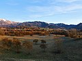 Landscape in Valpiana
 -
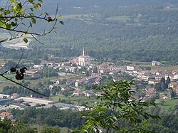
 the town with the parish Church


References
- ^ "Superficie di Comuni Province e Regioni italiane al 9 ottobre 2011". Italian National Institute of Statistics. Retrieved 16 March 2019.
- ^ "Popolazione Residente al 1° Gennaio 2018". Italian National Institute of Statistics. Retrieved 16 March 2019.
- ^ All demographics and other statistics: Italian statistical institute Istat.
External links
Wikimedia Commons has media related to Limana.
- Official website
- v
- t
- e
- Agordo
- Alleghe
- Alpago
- Arsiè
- Auronzo di Cadore
- Belluno
- Borca di Cadore
- Borgo Valbelluna
- Calalzo di Cadore
- Canale d'Agordo
- Cencenighe Agordino
- Cesiomaggiore
- Chies d'Alpago
- Cibiana di Cadore
- Colle Santa Lucia
- Comelico Superiore
- Cortina d'Ampezzo
- Danta di Cadore
- Domegge di Cadore
- Falcade
- Feltre
- Fonzaso
- Gosaldo
- La Valle Agordina
- Lamon
- Limana
- Livinallongo del Col di Lana
- Longarone
- Lorenzago di Cadore
- Lozzo di Cadore
- Ospitale di Cadore
- Pedavena
- Perarolo di Cadore
- Pieve di Cadore
- Ponte nelle Alpi
- Rivamonte Agordino
- Rocca Pietore
- San Gregorio nelle Alpi
- San Nicolò di Comelico
- San Pietro di Cadore
- San Tomaso Agordino
- San Vito di Cadore
- Santa Giustina
- Santo Stefano di Cadore
- Sedico
- Selva di Cadore
- Seren del Grappa
- Setteville
- Sospirolo
- Soverzene
- Sovramonte
- Taibon Agordino
- Tambre
- Val di Zoldo
- Vallada Agordina
- Valle di Cadore
- Vigo di Cadore
- Vodo Cadore
- Voltago Agordino
- Zoppè di Cadore
| Authority control databases |
|
|---|


