Ligurian Sea
Arm of the Mediterranean Sea between the Italian Riviera (Liguria) and the island of Corsica


The Ligurian Sea (Italian: Mar Ligure; French: Mer Ligurienne; Ligurian: Mâ Ligure; Corsican: Mari Liguru) is an arm of the Mediterranean Sea. It lies between the Italian Riviera (Liguria) and the island of Corsica. The sea is thought to have been named after the ancient Ligures people.
Geography
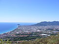
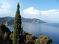
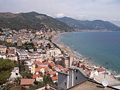
The sea borders Italy as far as its border with France, and the French island of Corsica. In the east, the sea borders the Tyrrhenian Sea, while in the west it borders the Mediterranean Sea proper. Genoa is the most prominent city in the area. The northwest coast is noted for its scenic beauty and favourable climate.
The Gulf of Genoa is its northernmost part. The ports of Genoa and La Spezia are on its rocky coast. It reaches a maximum depth of more than 2,800 m (9,300 ft) northwest of Corsica.
According to a 1983 study, since 1977 a series of experimental analyses on sea-level variations at Genoa and Imperia highlighted "the existence of a seiche wave with a mean period of 5.8 hours", whose reasons weren't yet explained at that time. The Ligurian Sea was modeled as a rectangular semi-closed basin with a longitudinal length of 40 km (25 mi) and a transversal one of 10 km (6.2 mi), in an average constant depth of 2,000 m (6,600 ft; 1,100 fathoms).[1]
Extent
The International Hydrographic Organization defines the limits of the Ligurian Sea as follows:[2]
On the Southwest. A line joining Cape Corse (Cape Grosso, 9°23′E) the Northern point of Corsica to the frontier between France and Italy (7°31′E).
On the Southeast. A line joining Cape Corse with Tinetto Island (44°01′N 9°51′E / 44.017°N 9.850°E / 44.017; 9.850) and thence through Tino and Palmaria Islands to San Pietro Point (44°03′N 9°50′E / 44.050°N 9.833°E / 44.050; 9.833) on the Coast of Italy.
On the North The Ligurian Coast of Italy.
Flowings
The Ligurian Sea is attraversed by the Modified Atlantic Water (MAW) on its surface and by the Levantine Intermediate Water in depth. It is also brushed by the two main currents which surround the Corsica island: the Western Corsica Current and the Tyrrenian current that reaches the Corsica Channel.[3]
Conservation
In order to provide protection for the numerous cetacean (whales and dolphins; porpoises are not found in this part of the Mediterranean Sea) species in the Ligurian Sea the bordering countries established the sea as a SPAMI in 1999. The International Ligurian Sea Cetacean Sanctuary now covers 84,000 km2 (32,000 sq mi) covering territorial waters as well as high sea.
Image gallery
-

-

-
-
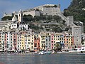
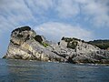 Palmaria
 -
-

-

-

-

-

-

-

-

-
-
-
-

-

-


References
Wikimedia Commons has media related to Ligurian Sea.
- ^ Papa, Lorenzo (1 December 1983). "A numerical computation of a seiche oscillation of the Ligurian Sea". Geophysical Journal International. 75 (3). Oxford University Press: 659–667. Bibcode:1983GeoJ...75..659P. doi:10.1111/j.1365-246X.1983.tb05004.x. ISSN 0956-540X. OCLC 4640460944.
- ^ "Limits of Oceans and Seas, 3rd edition" (PDF). International Hydrographic Organization. 1953. Archived from the original (PDF) on 5 October 2018. Retrieved 28 December 2020.
- ^ Vignudelli, S.; Cipollini, P.; Reseghetti, F.; Fusco, G.; Gasparini, G. P.; Manzella, G. M. R. (2003). "Comparison between XBT data and TOPEX/Poseidon satellite altimetry in the Ligurian-Tyrrhenian area" (pdf). Annales Geophysicae. 21 (21). European Geosciences Union: 123–135. Bibcode:2003AnGeo..21..123V. doi:10.5194/angeo-21-123-2003. ISSN 0992-7689. Archived (PDF) from the original on November 20, 2008. At the introductory paragraph.
- v
- t
- e
- Adriatic Sea
- Aegean Sea
- Alboran Sea
- American Mediterranean Sea
- Archipelago Sea
- Argentine Sea
- Baffin Bay
- Balearic Sea
- Baltic Sea
- Bay of Biscay
- Bay of Bothnia
- Bay of Campeche
- Bay of Fundy
- Black Sea
- Bothnian Sea
- Caribbean Sea
- Celtic Sea
- English Channel
- Foxe Basin
- Greenland Sea
- Gulf of Bothnia
- Gulf of Finland
- Gulf of Lion
- Gulf of Guinea
- Gulf of Maine
- Gulf of Mexico
- Gulf of Saint Lawrence
- Gulf of Sidra
- Gulf of Venezuela
- Hudson Bay
- Ionian Sea
- Irish Sea
- Irminger Sea
- James Bay
- Labrador Sea
- Levantine Sea
- Libyan Sea
- Ligurian Sea
- Marmara Sea
- Mediterranean Sea
- Myrtoan Sea
- North Sea
- Norwegian Sea
- Sargasso Sea
- Sea of Åland
- Sea of Azov
- Sea of Crete
- Sea of the Hebrides
- Thracian Sea
- Tyrrhenian Sea
- Wadden Sea
- Arafura Sea
- Bali Sea
- Banda Sea
- Bering Sea
- Bismarck Sea
- Bohai Sea
- Bohol Sea
- Camotes Sea
- Celebes Sea
- Chilean Sea
- Coral Sea
- East China Sea
- Gulf of Alaska
- Gulf of Anadyr
- Gulf of California
- Gulf of Carpentaria
- Gulf of Fonseca
- Gulf of Panama
- Gulf of Thailand
- Gulf of Tonkin
- Halmahera Sea
- Java Sea
- Koro Sea
- Mar de Grau
- Molucca Sea
- Moro Gulf
- Philippine Sea
- Salish Sea
- Savu Sea
- Sea of Japan
- Sea of Okhotsk
- Seram Sea
- Seto Inland Sea
- Shantar Sea
- Sibuyan Sea
- Solomon Sea
- South China Sea
- Sulu Sea
- Tasman Sea
- Visayan Sea
- Yellow Sea
 Oceans portal
 Category

Marginal seas of the Atlantic Ocean | |
|---|---|
| Basins | |
| Bays | |
| Channels | |
| Gulfs | |
| Seas |
|
 Oceans portal Oceans portal | |
43°30′N 9°00′E / 43.500°N 9.000°E / 43.500; 9.000
Authority control databases | |
|---|---|
| International |
|
| National |
|
| Geographic |
|


