Kumachyovo
You can help expand this article with text translated from the corresponding article in German. (June 2016) Click [show] for important translation instructions.
- Machine translation, like DeepL or Google Translate, is a useful starting point for translations, but translators must revise errors as necessary and confirm that the translation is accurate, rather than simply copy-pasting machine-translated text into the English Wikipedia.
- Do not translate text that appears unreliable or low-quality. If possible, verify the text with references provided in the foreign-language article.
- You must provide copyright attribution in the edit summary accompanying your translation by providing an interlanguage link to the source of your translation. A model attribution edit summary is
Content in this edit is translated from the existing German Wikipedia article at [[:de:Kumatschowo (Kaliningrad, Selenogradsk)]]; see its history for attribution. - You may also add the template
{{Translated|de|Kumatschowo (Kaliningrad, Selenogradsk)}}to the talk page. - For more guidance, see Wikipedia:Translation.
Rural locality in Kaliningrad Oblast, Russia
Kumachyovo Кумачёво | |
|---|---|
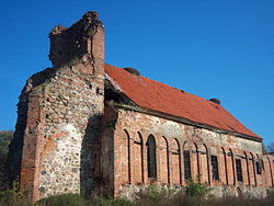 Medieval church ruins | |
Location of Kumachyovo  | |
54°49′16″N 20°12′50″E / 54.821°N 20.214°E / 54.821; 20.214 | |
| Country | Russia |
| Federal subject | Kaliningrad Oblast |
| Administrative district | Zelenogradsky District |
| Elevation | 71 m (233 ft) |
| Population (2010 Census)[1] | |
| • Total | 541 |
| Time zone | UTC+2 (MSK–1 |
| Postal code(s)[3] | 238542 |
| OKTMO ID | 27710000611 |
Kumachyovo or Kumachevo (Russian: Кумачёво; German: Kumehnen; Lithuanian: Kumėnai) is a rural settlement in Zelenogradsky District, Kaliningrad Oblast, Russia, part of the Pereslavskoye rural municipality.[4] It is located on the Sambian Peninsula.
History
The local Gothic church was built in 1390.[5] In 1454, King Casimir IV Jagiellon incorporated the region to the Kingdom of Poland upon the request of the anti-Teutonic Prussian Confederation.[6] After the subsequent Thirteen Years' War (1454–1466), it became a part of Poland as a fief held by the Teutonic Knights until 1525,[7] and by Ducal Prussia afterwards.
From the 18th century it formed part of the Kingdom of Prussia, and from 1871 it was also part of the German Empire, within which it was located in the province of East Prussia. After Germany's defeat in World War II, in 1945, it passed to the Soviet Union. In the post-war period, the abandoned church gradually deteriorated.[5]
References
- ^ Russian Federal State Statistics Service (2011). Всероссийская перепись населения 2010 года. Том 1 [2010 All-Russian Population Census, vol. 1]. Всероссийская перепись населения 2010 года [2010 All-Russia Population Census] (in Russian). Federal State Statistics Service.
- ^ "Об исчислении времени". Официальный интернет-портал правовой информации (in Russian). 3 June 2011. Retrieved 19 January 2019.
- ^ Почта России. Информационно-вычислительный центр ОАСУ РПО. (Russian Post). Поиск объектов почтовой связи (Postal Objects Search) (in Russian)
- ^ "Генеральный план МО «Переславское сельское поселение»". Archived from the original on 2016-04-04. Retrieved 2016-06-08.
- ^ a b "Die Kirchen im Samland / Genealogy East Prussia (Sambia)". Archived from the original on 2014-09-27. Retrieved 2016-06-08.
- ^ Górski, Karol (1949). Związek Pruski i poddanie się Prus Polsce: zbiór tekstów źródłowych (in Polish). Poznań: Instytut Zachodni. p. 54.
- ^ Górski, pp. 96–97, 214–215
- v
- t
- e


