Kosciusko, St. Louis
Neighborhood of St. Louis in Missouri, United States
Kosciusko | |
|---|---|
Neighborhood of St. Louis | |
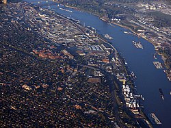 Barge traffic along the industrial riverfront, October 2006 | |
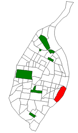 Location (red) of Kosciusko within St. Louis | |
| Country | United States |
| State | Missouri |
| City | St. Louis |
| Wards | 7, 9 |
| Area | |
| • Total | 1.13 sq mi (2.9 km2) |
| Population (2020)[1] | |
| • Total | 52 |
| • Density | 46/sq mi (18/km2) |
| ZIP code(s) | Parts of 63104, 63118 |
| Area code(s) | 314 |
| Website | stlouis-mo.gov |
Kosciusko (/kʌˈʃuskoʊ/ kuh-SHOOS-koh) is a mostly non-residential neighborhood located in St. Louis, Missouri. It begins at the Mississippi River front in the east and goes up to 7th Boulevard and 8th Street in the west. Interstate 55 is a northern border, and St. George and Dorcas Streets border the south of this neighborhood. Kosciusko is named in honor of Tadeusz Kościuszko, an American Revolutionary War general of Polish descent.
Within its limits are several industrial companies, including the Nooter Corporation. With a population of 52 in 2020, Kosciusko's racial makeup was 38.5% White, 30.8% Black, 0% Asian, 0% American Indian, 1.9% Pacific Islander, 26.9% Two or more races with 15.4% being of Hispanic origin.[2]
The longest continuous graffiti wall, the 1.9 Mile Mississippi River Floodwall, is in this neighborhood. It is home to the annual Labor Day event, Paint Louis.[3][4]
Schooling
The first independent charter middle school in the city is located in the neighborhood, as well. Lift for Life Academy, which opened in 2000, offers education for Grades K – 12.
Lyon Park
The City of Saint Louis maintains one city park within the Kosciusko boundaries: Lyon Park, named after Union Civil War General Nathaniel Lyon. It houses two softball fields, an asphalt walking trail, and both a monument to General Lyon (sculpted by Adolphus Druiding) and a statue of his likeness created by artist Charles Steubenraugh. Lyon Park is bounded by South Broadway, South Second Street, Utah Street, and Arsenal Street.
Demographics
| Census | Pop. | Note | %± |
|---|---|---|---|
| 1990 | 0 | — | |
| 2010 | 14 | — | |
| 2020 | 52 | 271.4% | |
| Sources:[5][6] | |||
References
- ^ "2020 Census Neighborhood Results".
- ^ "City of St. Louis" (PDF).
- ^ Bernhard, Jimmy (3 June 2016). "Our Beautiful City: Paint Louis Graffiti Wall". KSDK. Retrieved 26 August 2018.
- ^ "THE MURAL MILE (FLOODWALL)". Regional Arts Commission. Retrieved 26 August 2018.
- ^ "Kosciusko Neighborhood Statistics". St Louis, MO. Retrieved 26 January 2023.
- ^ "Neighborhood Census Data". City of St. Louis. Retrieved 26 January 2023.
Kosciusko of Lithuanian Heritage http://www.draugas.org/news/kosciusko-soldier-humanitarian-lithuanian/
External links
- Kosciusko neighborhood website
- v
- t
- e
- Academy
- Baden
- Benton Park
- Benton Park West
- Bevo Mill
- Botanical Heights
- Boulevard Heights
- Carondelet
- Carr Square
- Central West End
- Cheltenham
- Chinatown (defunct since 1966)
- Clayton/Tamm
- Clifton Heights
- College Hill
- Columbus Square
- Compton Heights
- Covenant Blu Grand Center
- DeBaliviere Place
- "Dogtown"
- Downtown
- Downtown West
- Dutchtown
- Ellendale
- Fairground
- Forest Park Southeast
- Fountain Park
- Fox Park
- Franz Park
- Gate District
- Gravois Park
- Greater Ville
- Hamilton Heights
- The Hill
- Hi-Pointe
- Holly Hills
- Hyde Park
- JeffVanderLou
- Kings Oak
- Kingsway East
- Kingsway West
- Kosciusko
- Lafayette Square
- LaSalle Park
- Lewis Place
- Lindenwood Park
- Marine Villa
- Mark Twain
- Mark Twain/I-70 Industrial
- McKinley Heights
- Midtown
- Mill Creek Valley (defunct since 1960s)
- Mount Pleasant
- Near North Riverfront
- Northampton
- North Point
- North Riverfront
- O'Fallon
- Old North St. Louis
- Patch
- Peabody–Darst–Webbe
- Penrose
- Princeton Heights
- Riverview
- Shaw
- Skinker DeBaliviere
- Soulard
- Southampton
- Southwest Garden
- St. Louis Hills
- St. Louis Place
- Tiffany
- Tower Grove East
- Tower Grove South
- Vandeventer
- The Ville
- Visitation Park
- Walnut Park East
- Walnut Park West
- Wells/Goodfellow
- West End
- Wydown/Skinker
38°36′11″N 90°11′57″W / 38.6031°N 90.1993°W / 38.6031; -90.1993
 | This St. Louis location article is a stub. You can help Wikipedia by expanding it. |
- v
- t
- e


