Kirby Grindalythe
Village and civil parish in North Yorkshire, England
Human settlement in England
- Kirby Grindalythe
- North Yorkshire
- North Yorkshire
- Thirsk and Malton
Kirby Grindalythe is a village and civil parish in North Yorkshire, England. It is situated about 8 miles (13 km) south-east of Malton. The village lies in the Great Wold Valley and the course of the winterbourne stream the Gypsey Race passes through it.
History
The name of the village is derived from Old Norse. Kirby kirkiubỹr means "village with a church", the Grindal element is a distortion of Cranedale, meaning "valley with cranes" and lythe is from Old Norse "hlíõ" meaning slope.[2] Kirby Grindalythe was mentioned in the Domesday Book as being in the Hundred of Toreshou (Buckrose), belonging to King William, and having one ploughland.[3] The settlement was built around its parish church in the upper Gypsey Race Valley, and in Medieval times, it was the most important settlement in the area.[4]
Kirby Grindalythe village has a resident population of roughly fifty. There are no shops, pubs or other services and the nearest town is Malton. The church of St Andrew's at Kirby Grindalythe is on the Sykes Churches Trail having been restored by Sir Tatton Sykes in 1872–5 and again more recently after a grant of about £175,000 from English Heritage.[5] The church is now a Grade II* listed building.[6]
The village is also the location of the Cranedale Centre, a residential Field Studies Centre providing courses in environmental subjects and outdoor education to people of all ages. The centre operates from a converted farm and has been open since 1983.[7]
Governance
The civil parish of Kirby Grindalythe, which includes the village of Duggleby, had a population of 247 people living in 92 households at the time of the 2001 Census.[8] The population at the 2011 Census had risen to 295.[1] In 1823 Kirby Grindalythe was a civil parish with a population of 178 in the Wapentake of Buckrose.[9] It was historically part of the Norton Rural District in the East Riding of Yorkshire until 1974.[10] Between 1974 and 2023 the parish was part of the Ryedale district. It is now administered by North Yorkshire Council.[11][12] It is represented at Westminster as part of the Thirsk and Malton Constituency.[13]
| 1801 | 1811 | 1821 | 1831 | 1841 | 1851 | 1861 | 1871 | 1881 | 1891 | 1901 | 1911 | 1921 | 1931 | 1951 | 1961 | 1971 | 1981 | 1991 | 2001 | 2011 | 2015 |
|---|---|---|---|---|---|---|---|---|---|---|---|---|---|---|---|---|---|---|---|---|---|
| 276 | 311 | 376 | 414 | 474 | 554 | 571 | 566 | 534 | 449 | 415 | 411 | 359 | 332 | 327 | 303 | 291 | 290 | 284 | 247 | 295 | 350[a] |
- ^ Estimated population.
High Mowthorpe
Also in the civil parish is the former hamlet of High Mowthorpe (54°06′29″N 0°38′32″W / 54.10819°N 0.64231°W / 54.10819; -0.64231 (High Mowthorpe) ),[17] which is now an ADAS farm and arable research centre. The farm is a mixed arable and livestock farm, covering 437 hectares (1,080 acres) with 97 hectares (240 acres) managed organically.[18] Laboratory and glasshouse facilities are located on the site as well as a weather station providing data to the Met Office.[19] High Mowthorpe is also the home of ADAS Pest Evaluation Services, which processes approximately 4,000 soil and plant samples annually to determine pest and disease levels.
| Climate data for High Mowthorpe: Average maximum and minimum temperatures, and average rainfall recorded between 1991 and 2020 by the Met Office. elevation: 175 m (574 ft) | |||||||||||||
|---|---|---|---|---|---|---|---|---|---|---|---|---|---|
| Month | Jan | Feb | Mar | Apr | May | Jun | Jul | Aug | Sep | Oct | Nov | Dec | Year |
| Mean daily maximum °C (°F) | 5.7 (42.3) | 6.4 (43.5) | 8.6 (47.5) | 11.4 (52.5) | 14.4 (57.9) | 17.3 (63.1) | 19.9 (67.8) | 20.0 (68.0) | 16.8 (62.2) | 12.7 (54.9) | 8.7 (47.7) | 6.2 (43.2) | 12.4 (54.3) |
| Mean daily minimum °C (°F) | 0.9 (33.6) | 1.0 (33.8) | 2.1 (35.8) | 3.8 (38.8) | 6.3 (43.3) | 8.9 (48.0) | 11.0 (51.8) | 11.3 (52.3) | 9.6 (49.3) | 6.9 (44.4) | 3.7 (38.7) | 1.3 (34.3) | 5.6 (42.1) |
| Average precipitation mm (inches) | 64.8 (2.55) | 55.5 (2.19) | 48.8 (1.92) | 55.4 (2.18) | 51.4 (2.02) | 75.0 (2.95) | 63.6 (2.50) | 71.8 (2.83) | 62.3 (2.45) | 72.5 (2.85) | 79.3 (3.12) | 70.6 (2.78) | 771.1 (30.36) |
| Average precipitation days (≥ 1.0 mm) | 12.6 | 11.7 | 9.8 | 9.5 | 9.4 | 10.6 | 10.6 | 11.1 | 9.7 | 12.2 | 13.7 | 12.6 | 133.6 |
| Mean monthly sunshine hours | 54.8 | 81.2 | 120.9 | 161.0 | 208.5 | 188.4 | 198.0 | 181.2 | 141.6 | 104.3 | 65.8 | 51.1 | 1,557.1 |
| Source: Met Office[20] | |||||||||||||
Gallery
-
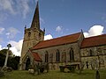 St Andrew's Church
 -
 Interior of St Andrew's


References
- ^ a b c UK Census (2011). "Local Area Report – Kirby Grindalythe Parish (1170217258)". Nomis. Office for National Statistics. Retrieved 16 March 2018.
- ^ Ekwall, Eilert (1980). The Concise Oxford Dictionary of English Place-names (Fourth ed.). Oxford: Oxford University Press. p. 279. ISBN 0-19-869103-3.
- ^ "Kirby [Grindalythe] | Domesday Book". opendomesday.org. Retrieved 9 September 2024.
- ^ Historic England. "Kirby Grindalythe medieval settlement earthworks immediately south west of St Andrew's Church (1017069)". National Heritage List for England. Retrieved 9 September 2024.
- ^ "Kirby Grindalythe Succeeded — So Can You!". www.eychurches.org.uk. 2007. Archived from the original on 27 February 2012. Retrieved 8 December 2014.
- ^ Historic England. "Church of St Andrew (1174946)". National Heritage List for England. Retrieved 8 December 2014.
- ^ "Cranedale Centre | Field Studies Centre - Residential Field Studies Centre". carnedale.com. Retrieved 9 September 2024.
- ^ UK Census (2001). "Local Area Report – Kirby Grindalythe Parish (1543510553)". Nomis. Office for National Statistics. Retrieved 25 November 2018.
- ^ Baines, Edward (1823): History, Directory and Gazetteer of the County of York, p. 361
- ^ Guide No. 6 North Yorkshire gazetteer of townships and parishes. Northallerton: archivesunlocked.northyorks.gov.uk. 2021 [1986]. p. 18. ISBN 0-906035-29-5.
- ^ Hoult, Philip (18 May 2023). "New unitary expresses concern at procedure adopted by abolished predecessor authority over CIL grant payments". Local Government Lawyer. Retrieved 9 September 2024.
- ^ "North Yorkshire councils scrapped and replaced with one authority". BBC News. 21 July 2021. Retrieved 9 September 2024.
- ^ "Election Maps". ordnancesurvey.co.uk. Retrieved 9 September 2024.
On the left of the screen is the "Boundary" tab; click this and activate either civil parishes or Westminster Constituencies (or both), however, only two functions can be active at any one time.
- ^ Neave, David; Neave, Susan (2008). A history of the county of York, East Riding. vol. 8: East Buckrose: Sledmere and the Northern Wolds / David Neave and Susan Neave. Woodbridge: Boydell & Brewer. p. 127. ISBN 978-1-90435-613-4.
- ^ UK Census (2001). "Local Area Report – Kirby Grindalythe Parish (36UF059)". Nomis. Office for National Statistics. Retrieved 9 September 2024.
- ^ "2015 Population Estimates: Parishes" (PDF). northyorks.gov.uk. December 2016. p. 16. Archived from the original (PDF) on 4 June 2022. Retrieved 9 September 2024.
- ^ "Kirby Grindalythe Parish information from Bulmers' 1892". Genuki. 2008. Retrieved 10 November 2009.
- ^ "High Mowthorpe". ADAS. Archived from the original on 3 September 2011. Retrieved 10 November 2009.
- ^ "Met Office: search results". Met Office. Archived from the original on 26 August 2011. Retrieved 10 November 2009.
- ^ "High Mowthorpe 1991–2020 averages". The Met Office. Retrieved 7 September 2024.
External links
 Media related to Kirby Grindalythe at Wikimedia Commons
- Kirby Grindalythe in the Domesday Book
Portals:
 Yorkshire
 England
 United Kingdom

- v
- t
- e
Yorkshire Portal
(cities in italics)
- Bedale
- Bentham
- Boroughbridge
- Catterick Garrison
- Colburn
- Easingwold
- Eastfield
- Eston
- Filey
- Grassington
- Guisborough
- Harrogate
- Hawes
- Haxby
- Helmsley
- Ingleby Barwick
- Kirkbymoorside
- Knaresborough
- Leyburn
- Loftus
- Malton
- Masham
- Middleham
- Middlesbrough
- Northallerton
- Norton-on-Derwent
- Pateley Bridge
- Pickering
- Redcar
- Richmond
- Ripon
- Saltburn-by-the-Sea
- Scarborough
- Selby
- Settle
- Skelton-in-Cleveland
- Skipton
- Stokesley
- Tadcaster
- Thirsk
- Thornaby-on-Tees
- Whitby
- Yarm
- York
See also: List of civil parishes in North Yorkshire


