Keetmanshoop Airport
Airport


Keetmanshoop
Location of airport in Namibia
| Direction | Length | Surface | |
|---|---|---|---|
| m | ft | ||
| 04/22 | 2,316 | 7,598 | Asphalt |
| 18/36 | 1,434 | 4,705 | Gravel |
Sources: Namibia Airports Co.[2] WAD[3] GCM[4]
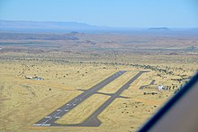
Keetmanshoop Airport (IATA: KMP, ICAO: FYKT) is an airport serving Keetmanshoop, a city in the ǁKaras Region of Namibia. The airport is located about 5 km (3 mi) northwest of the town.[5] It has customs and immigration services and is home to the Namibia Aviation Training Academy (NATA).[2]
The Keetmanshoop VOR-DME (Ident: KTV) is located on the field. The Keetmanshoop non-directional beacon (Ident: KT) is located 1.0 nautical mile (1.9 km) off the threshold of Rwy 04.[6][7]
See also
- List of airports in Namibia
- Transport in Namibia
References
- ^ "Namibia Airports Company: Airport Information". Retrieved 2017-05-04.
- ^ a b "Keetmanshoop Airport". Namibia Airports Company, Ltd. Retrieved 4 May 2017.
- ^ Airport information for FYKT[usurped]
- ^ Airport information for Keetmanshoop at Great Circle Mapper.
- ^ "Distance from Keetmanshoop to airport". WikiMapia. Retrieved 18 Feb 2010.
- ^ "Keetmanshoop VOR-DME (KTV) @ OurAirports". ourairports.com. Retrieved 2018-08-21.
- ^ "KTV - KEETMANSHOOP". www.pilotnav.com. Retrieved 2018-08-21.
Wikimedia Commons has media related to Keetmanshoop Airport.
External links
- Current weather for FYKT at NOAA/NWS
- SkyVector - Keetmanshoop
- OurAirports - Keetmanshoop
- OpenStreetMap - Keetmanshoop
Portals:
 Africa
 Aviation


- v
- t
- e
Airports in Namibia
- Walvis Bay
- Windhoek-Hosea Kutako
- Windhoek-Eros


