Karmirgyugh
40°19′50″N 45°11′02″E / 40.33056°N 45.18389°E / 40.33056; 45.18389
Place in Gegharkunik, Armenia
Karmirgyugh Կարմիրգյուղ | |
|---|---|
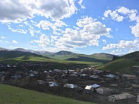
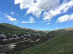 A view of Karmirgyugh | |
  Karmirgyugh  Karmirgyugh | |
| Coordinates: 40°19′50″N 45°11′02″E / 40.33056°N 45.18389°E / 40.33056; 45.18389 | |
| Country | Armenia |
| Province | Gegharkunik |
| Municipality | Gavar |
| Founded | 1831 |
| Population (2011)[1] | |
| • Total | 4,964 |
| Time zone | UTC+4 (AMT) |
| Karmirgyugh at GEOnet Names Server | |
Karmirgyugh (Armenian: Կարմիրգյուղ, lit. 'Red Village') is a village in the Gavar Municipality of the Gegharkunik Province of Armenia.
Etymology
The village is also known as Gyukh, and was known as Kulali and Ghulali until 1940.
History
The village was founded in 1831 by emigrants from Gavar. It contains two churches with khachkars, St. Astvatsatsin and St. Grigor, and was the discovery site of a boundary stone of King Artashes, inscribed in Aramaic. There are also Urartian ruins nearby.[2]
Gallery
-
 St. Astvatsatsin Church
 -
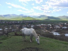 Scenery around Karmirgyugh
 -
 St. Grigor Church
 -
 A view of Karmirgyugh and surrounding mountains
 -
 St. Grigor Church and khachkars
 -
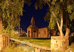 St. Astvatsatsin Church


References
- ^ Statistical Committee of Armenia. "The results of the 2011 Population Census of Armenia" (PDF).
- ^ Kiesling, Brady; Kojian, Raffi (2005). Rediscovering Armenia: Guide (2nd ed.). Yerevan: Matit Graphic Design Studio. p. 78. ISBN 99941-0-121-8.
External links
Wikimedia Commons has media related to Karmirgyugh.
- Report of the results of the 2001 Armenian Census, Statistical Committee of Armenia
- Kiesling, Brady (June 2000). Rediscovering Armenia: An Archaeological/Touristic Gazetteer and Map Set for the Historical Monuments of Armenia (PDF). Archived (PDF) from the original on 6 November 2021.
- v
- t
- e

Capital: Gavar

- Berdkunk
- Gandzak
- Gegharkunik
- Hayravank
- Karmirgyugh
- Lanjaghbyur
- Lchap
- Noratus
- Sarukhan
- Tsaghkashen
- Tsovazard
- Akhpradzor
- Akunk
- Areguni
- Arpunk
- Avazan
- Ayrk
- Azat
- Daranak
- Geghakar
- Geghamabak
- Geghamasar
- Jaghatsadzor
- Kakhakn
- Karchaghbyur
- Khachaghbyur
- Kut
- Kutakan
- Lchavan
- Lusakunk
- Makenis
- Mets Masrik
- Nerkin Shorzha
- Norabak
- Norakert
- Pambak
- Pokr Masrik
- Shatjrek
- Shatvan
- Sotk
- Torfavan
- Tretuk
- Tsovak
- Vanevan
- Verin Shorzha
- Zariver
Portal:
 Geography

 | This article about a location in Gegharkunik Province, Armenia is a stub. You can help Wikipedia by expanding it. |
- v
- t
- e


