Kadışehri District
District of Yozgat Province, Turkey
District in Yozgat, Turkey
39°59′N 35°49′E / 39.983°N 35.817°E / 39.983; 35.817 (2022)
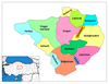
Kadışehri District is a district of the Yozgat Province of Turkey. Its seat is the town of Kadışehri.[1] Its area is 472 km2,[2] and its population is 10,004 (2022).[3] Neighbouring districts are Zile on the north, Akdağmadeni and Saraykent on the south, Çekerek on the west and Sulusaray on the east.
Composition
There are two municipalities in Kadışehri District:[1][4]
There are 19 villages in Kadışehri District:[5]
- Akçakale
- Aşağıkızılöz
- Buzluk
- Çamsaray
- Derbent
- Dikmesöğüt
- Elmalıçiftliği
- Elmalıütüğü
- Gümüşsu
- Hanözü
- Kabalı
- Kemalli
- Kıyılı
- Örencik
- Ovacık
- Seyhan
- Yanık
- Yavıhasan
- Yelten
References
- ^ a b İlçe Belediyesi, Turkey Civil Administration Departments Inventory. Retrieved 22 May 2023.
- ^ "İl ve İlçe Yüz ölçümleri". General Directorate of Mapping. Retrieved 22 May 2023.
- ^ "Address-based population registration system (ADNKS) results dated 31 December 2022, Favorite Reports" (XLS). TÜİK. Retrieved 22 May 2023.
- ^ Belde Belediyesi, Turkey Civil Administration Departments Inventory. Retrieved 22 May 2023.
- ^ Köy, Turkey Civil Administration Departments Inventory. Retrieved 22 May 2023.
- v
- t
- e
Kadışehri District in Yozgat Province of Turkey

| Istanbul | |
|---|---|
| West Marmara | |
| Aegean | |
| East Marmara | |
| West Anatolia | |
| Mediterranean | |
| Central Anatolia | |
| West Black Sea | |
| East Black Sea | |
| Northeast Anatolia | |
| Central East Anatolia | |
| Southeast Anatolia | |
Metropolitan municipalities are bolded.
 Kadışehri District Kadışehri District | |
|---|---|
| Municipalities | |
| Villages |
|
 | This geographical article about a location in Yozgat Province, Turkey is a stub. You can help Wikipedia by expanding it. |
- v
- t
- e


