Jeungpyeong County
County in Hoseo, South Korea
Jeungpyeong  Flag | |
|---|---|
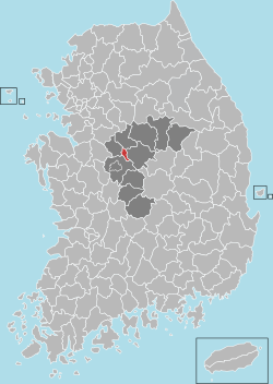 Location in South Korea | |
| Country |  South Korea South Korea |
| Region | Hoseo |
| Administrative divisions | 1 eup, 1 myeon |
| Area | |
| • Total | 81.84 km2 (31.60 sq mi) |
| Population (2008) | |
| • Total | 31,276 |
| • Density | 382/km2 (990/sq mi) |
| • Dialect | Chungcheong |
| Website | jp.go.kr |
Jeungpyeong County (Korean: 증평군; RR: Jeungpyeong-gun) is a county in North Chungcheong Province, South Korea.
Location
Jeungpyeong is in the centrally located in Chungcheongbuk-do. It is located East of Jincheon, West of Goesan, south of Eumseong, north of Cheongwon.
Symbols
- county tree: Ginkgo tree
- county bird: Snowy Egret
- county flower: White Magnolia
History
- 1990, 12, 31 : Chungcheongbuk-do Jeungpyeong local office is construct of Goesan-gun jeungpyeong eup, doan myeon.
- 2003, 8, 30 : Jeungpyeong local office is raised to Jeungpyeong-gun, and it became independence from Goesan-gun.
Education
- Jeungpyeong is the site of several school and tertiary institutions, including:
Elementary school
- Doan Elementary School
- Jeungpyeong Elementary School
- Jukri Elementary School
- Sambo Elementary School
Middle school
- Hyeongseok Middle School
- Jeungpyeong Middle School
- Jeungpyeong Girl's Middle School
High school
- Chungbuk Business High School
- Hyeongseok High School
- Jeungpyeong Technical High School
Tertiary Institution
- Korea National University of Transportation
Twin towns – sister cities
Jeungpyeong is twinned with:
 Guannan County, Jiangsu, China

References
External links
- Jeungpyeong County government home page

Authority control databases | |
|---|---|
| International |
|
| National |
|
36°47′N 127°35′E / 36.783°N 127.583°E / 36.783; 127.583
 | This South Korea location article is a stub. You can help Wikipedia by expanding it. |
- v
- t
- e


