Isla de sa Porassa is located in the bay of the village of Magaluf, Majorca, Spain.
Features
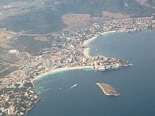
Sa Porrassa and Magaluf
Measuring over 400 meters (1,300 ft) across at its widest point, the island is a feature at the heart of Magaluf Bay. It is 36 m (118 ft) above sea level.[1] The island is uninhabited, but visited during the summer season by many holidaymakers, either swimming, on personal water craft or on pedalboat from Magaluf Beach.
[2]
References
^Publications. Vol. 151 (Digitized May 5, 2009 ed.). United States. Hydrographic Office. 1920. p. 221.
^"Magalluf Guide". Archived from the original on 27 June 2010. Retrieved 6 July 2010.