Huambo volcanic field
15°50′S 72°08′W / 15.83°S 72.13°W / -15.83; -72.13[1]
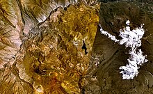
Huambo volcanic field is a volcanic field in Peru. Andahua-Orcopampa lies north-northeast and Sabancaya east of Huambo,[1] east of the Rio Colca.[2] The town of Huambo lies between the two fields.[3]
The northern part of the field was active 700 BCE ± 50 years, forming a large lava flow field and a cinder cone Cerro Keyocc. The southern part of the field contains other cinder cones and lava flows. Some may be of Holocene age.[1] Lava flows are a few 10 metres (33 ft) thick. Four among the volcanoes of the southern field are Marbas Grande, Marbas, Marbas Chico I and Marbas Chico II.[2] The formation of these fields may have been influenced by magma ascent along deep fault systems.[4]
Trachyandesite is the major eruption product of Huambo.[1] The magmas forming this field formed in deep magma chambers with little modification in shallower magma chambers.[2] Basement lava flows have been dated at 1.05±0.04 mya.[3] The Huambo field is located within the Arequipa crustal domain.[4]
References
- ^ a b c d "Huambo". Global Volcanism Program. Smithsonian Institution.
- ^ a b c Delacour, Adélie; Gerbe, Marie-Christine; Thouret, Jean-Claude; Wörner, Gerhard; Paquereau-Lebti, Perrine (17 November 2006). "Magma evolution of Quaternary minor volcanic centres in southern Peru, Central Andes" (PDF). Bulletin of Volcanology. 69 (6): 581–608. doi:10.1007/s00445-006-0096-z. hdl:20.500.11850/67949.
- ^ a b Andean Volcanism: Nevado Hualca Hualca Volcano, Southern Peru, and El Reventador Volcano, Ecuador. ProQuest. 2008. pp. 34–35. ISBN 978-0-549-36997-4.
- ^ a b Mamani, M.; Worner, G.; Sempere, T. (25 September 2009). "Geochemical variations in igneous rocks of the Central Andean orocline (13 S to 18 S): Tracing crustal thickening and magma generation through time and space". Geological Society of America Bulletin. 122 (1–2): 162–182. doi:10.1130/B26538.1.
- v
- t
- e
Andean volcanoes
(6° N – 3° S)
- Paipa-Iza
- Romeral
- Cerro Bravo
- Nevado del Ruiz
- Nevado del Tolima
- Nevado del Huila
- Puracé
- Doña Juana
- Galeras
- Azufral
- Chiles
- Cayambe
- Reventador
- Pichincha
- Antisana
- Aliso
- Soche
- Illiniza
- Cotopaxi
- Quilotoa
- Chimborazo
- Tungurahua
- Licto volcanic field
- Sangay
(14°–27° S)
- Quimsachata
- Auquihuato
- Firura
- Sara Sara
- Solimana
- Coropuna
- Hualca Hualca
- Sabancaya
- Huambo volcanic field
- Ampato
- Andagua volcanic field
- Chachani
- Misti
- Ubinas
- Pichu Pichu
- Huaynaputina
- Ticsani
- Tutupaca
- Yucamane
- Purupuruni
- Casiri
- Tacora
- Taapaca
- Parinacota
- Lauca
- Guallatiri
- Tata Sabaya
- Isluga
- Irruputuncu
- Olca-Paruma
- Aucanquilcha
- Azufre
- Zapaleri
- Sairecabur
- Licancabur
- Purico complex
- Pacana
- Aguas Calientes
- Lascar
- Chiliques
- Aracar
- Socompa
- Llullaillaco
- Lastarria
- Lazufre
- Cordón del Azufre
- Galán
- Peinado
- San Francisco
- Cueros de Purulla
- Incahuasi
- Ojos del Salado
(33°–46° S)
- Tupungato
- Tupungatito
- Maipo
- Calabozos
- Descabezado Grande
- Cerro Azul
- Nevado de Longaví
- Nevados de Chillán
- Antuco
- Copahue
- Callaqui
- Lonquimay
- Llaima
- Sollipulli
- Villarrica
- Quetrupillán
- Lanín
- Mocho-Choshuenco
- Carrán-Los Venados
- Puyehue-Cordón Caulle
- Casablanca
- Osorno
- Calbuco
- Hornopirén
- Huequi
- Michinmahuida
- Chaitén
- Corcovado
- Mentolat
- Cay
- Macá
- Mate Grande
- Hudson
(49°–55° S)
Note: volcanoes are ordered by latitude from north to south
 | This volcanology article is a stub. You can help Wikipedia by expanding it. |
- v
- t
- e


