Grade I and II* listed buildings in the London Borough of Havering
Map all coordinates using OpenStreetMap
Download coordinates as:
- KML
- GPX (all coordinates)
- GPX (primary coordinates)
- GPX (secondary coordinates)
There are over 9,000 Grade I listed buildings and 20,000 Grade II* listed buildings in England. This page is a list of these buildings in the London Borough of Havering.
Grade I
| Name | Location | Type | Completed [note 1] | Date designated | Grid ref.[note 2] Geo-coordinates | Entry number [note 3] | Image |
|---|---|---|---|---|---|---|---|
| Church of St Helen and St Giles | Rainham, Havering | Church | c. 1170 | 7 January 1955 | TQ5208382208 51°31′06″N 0°11′26″E / 51.518324°N 0.190537°E / 51.518324; 0.190537 (Church of St Helen and St Giles) | 1358505 | 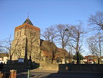 More images |
| Church of St Laurence | Upminster, Havering | Church | Medieval | 7 January 1955 | TQ5592986496 51°33′21″N 0°14′52″E / 51.555802°N 0.247821°E / 51.555802; 0.247821 (Church of St Laurence) | 1184679 |  More images |
| Church of St Mary Magdalene | North Ockendon, Havering | Church | 12th century | 7 January 1955 | TQ5873984866 51°32′25″N 0°17′15″E / 51.540374°N 0.287585°E / 51.540374; 0.287585 (Church of St Mary Magdalene) | 1183610 |  More images |
| Parish Church of St Andrew | Hornchurch, Havering | Parish Church | 13th century | 7 January 1955 | TQ5440986968 51°33′38″N 0°13′34″E / 51.56046°N 0.226121°E / 51.56046; 0.226121 (Parish Church of St Andrew) | 1358529 |  More images |
| The Bower House | Havering-atte-Bower, Havering | Country House | 1729 | 4 July 1952 | TQ5125492708 51°36′46″N 0°10′59″E / 51.612887°N 0.183113°E / 51.612887; 0.183113 (The Bower House) | 1079873 | 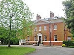 More images |
| Stable Block at the Bower House | Havering-atte-Bower, Havering | Stable | c. 1729 | 4 July 1952 | TQ5124392695 51°36′46″N 0°10′59″E / 51.612773°N 0.182949°E / 51.612773; 0.182949 (Stable Block at the Bower House) | 1079874 |  |
Grade II*
| Name | Location | Type | Completed [note 1] | Date designated | Grid ref.[note 2] Geo-coordinates | Entry number [note 3] | Image |
|---|---|---|---|---|---|---|---|
| Bretons | Hornchurch, Havering | House | Late 17th century | 7 January 1955 | TQ5169684862 51°32′32″N 0°11′10″E / 51.542274°N 0.186106°E / 51.542274; 0.186106 (Bretons) | 1079875 |  More images |
| Church of St Mary and St Peter | Wennington, Havering | Church | Medieval | 7 January 1955 | TQ5398780949 51°30′23″N 0°13′03″E / 51.506497°N 0.217408°E / 51.506497; 0.217408 (Church of St Mary and St Peter) | 1079886 |  More images |
| Great Tomkyns | Upminster, Havering | House | Modern | 7 January 1955 | TQ5666989498 51°34′57″N 0°15′35″E / 51.582568°N 0.259824°E / 51.582568; 0.259824 (Great Tomkyns) | 1184797 |  Upload Photo |
| Barn to North East of Great Tomkyns | Upminster, Havering | Barn | 1727 | 7 January 1955 | TQ5668589611 51°35′01″N 0°15′36″E / 51.583579°N 0.260105°E / 51.583579; 0.260105 (Barn to North East of Great Tomkyns) | 1358527 | Upload Photo |
| High House Farmhouse | Corbets Tey, Havering | House | c. 1700 | 7 January 1955 | TQ5622585025 51°32′33″N 0°15′05″E / 51.542504°N 0.251435°E / 51.542504; 0.251435 (High House Farmhouse) | 1079867 | 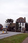 |
| Parish Church of St Edward the Confessor | Romford, Havering | Parish Church | 1849 | 4 July 1952 | TQ5119588957 51°34′45″N 0°10′50″E / 51.579201°N 0.180647°E / 51.579201; 0.180647 (Parish Church of St Edward the Confessor) | 1358535 |  More images |
| Rainham Hall | Rainham, Havering | House | 1729 | 7 January 1955 | TQ5209982164 51°31′05″N 0°11′27″E / 51.517924°N 0.190749°E / 51.517924; 0.190749 (Rainham Hall) | 1358506 |  More images |
| Forecourt Railings, Gates and Piers Walls and Vases at Rainham Hall | Rainham, Havering | Gate | Early 18th century | 7 January 1955 | TQ5208482158 51°31′04″N 0°11′26″E / 51.517874°N 0.19053°E / 51.517874; 0.19053 (Forecourt Railings, Gates and Piers Walls and Vases at Rainham Hall) | 1079922 |  More images |
| Stable Block at Rainham Hall | Rainham, Havering | Stable | 18th century | 7 January 1955 | TQ5211582153 51°31′04″N 0°11′28″E / 51.517821°N 0.190974°E / 51.517821; 0.190974 (Stable Block at Rainham Hall) | 1183554 |  |
| The Lodge at Rainham Hall | Rainham, Havering | House | Early 18th century | 7 January 1955 | TQ5209482149 51°31′04″N 0°11′26″E / 51.517791°N 0.19067°E / 51.517791; 0.19067 (The Lodge at Rainham Hall) | 1079923 |  More images |
| The Round House | Havering-atte-Bower, Havering | Villa | 1792 | 4 July 1952 | TQ5148893136 51°37′00″N 0°11′12″E / 51.61667°N 0.186675°E / 51.61667; 0.186675 (The Round House) | 1183562 | Upload Photo |
| The Royal Liberty School | Gidea Park, Havering | Country House | 1768-9 | 14 September 1979 | TQ5321289728 51°35′08″N 0°12′36″E / 51.585584°N 0.210069°E / 51.585584; 0.210069 (The Royal Liberty School) | 1079885 |  More images |
| Upminster Hall | Upminster, Havering | House | 17th century | 7 January 1955 | TQ5659287682 51°33′59″N 0°15′28″E / 51.566274°N 0.257904°E / 51.566274; 0.257904 (Upminster Hall) | 1079889 | Upload Photo |
| Upminster Windmill | Upminster, Havering | Smock Mill | Mid 19th century | 7 January 1955 | TQ5573486725 51°33′28″N 0°14′42″E / 51.557913°N 0.245112°E / 51.557913; 0.245112 (Upminster Windmill) | 1079878 |  More images |
| Wrought Iron Screen and Gates with Piers at Bretons | Hornchurch, Havering | Gate | c. 1740 | 7 January 1955 | TQ5173984853 51°32′32″N 0°11′12″E / 51.542181°N 0.186722°E / 51.542181; 0.186722 (Wrought Iron Screen and Gates with Piers at Bretons) | 1358521 | Upload Photo |
Notes
- ^ a b The date given is the date used by Historic England as significant for the initial building or that of an important part in the structure's description.
- ^ a b Sometimes known as OSGB36, the grid reference is based on the British national grid reference system used by the Ordnance Survey.
- ^ a b The "List Entry Number" is a unique number assigned to each listed building and scheduled monument by Historic England.
External links
 Media related to Grade I listed buildings in the London Borough of Havering at Wikimedia Commons
- Media related to Grade II* listed buildings in the London Borough of Havering at Wikimedia Commons
- v
- t
- e
- Ardleigh Green
- Beam Park
- Chase Cross
- Coldharbour
- Collier Row
- Cranham
- Elm Park
- Emerson Park
- Frog Island
- Gallows Corner
- Gidea Park
- Hacton
- Harold Hill
- Harold Park
- Harold Wood
- Havering-atte-Bower
- Heath Park
- Hornchurch
- Hornchurch Marshes
- Noak Hill
- North Ockendon
- Rainham
- Rise Park
- Romford
- Rush Green
- South Hornchurch
- Upminster
- Upminster Bridge
- Wennington


- The Brewery
- The Liberty
- The Mercury
- Romford Market
- Bedfords Park
- Cranham Brickfields
- Cranham Marsh
- Dagenham Park
- Hainault Forest
- Harrow Lodge Park
- Havering Country Park
- Haynes Park
- Hornchurch Country Park
- Hylands Park
- Ingrebourne Marshes
- Ingrebourne Valley
- Lodge Farm Park
- Pages Wood
- Pyrgo Park
- Rainham Marshes Nature Reserve
- Raphael Park
- St Andrew's Park
- Tylers Common
- Weald Brook
- Wildspace Conservation Park
- Dagenham and Rainham (part)
- Hornchurch and Upminster
- Romford


- Council
- Grade I and II* listed buildings
- People
- Public art
- Public transport
- Schools
 Category
- Commons

Portals:
 London
 Architecture


