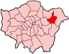
Grade I and II* listed buildings in the London Borough of Barking and Dagenham
Map all coordinates using OpenStreetMap
Download coordinates as:
- KML
- GPX (all coordinates)
- GPX (primary coordinates)
- GPX (secondary coordinates)
There are over 9,000 Grade I listed buildings and 20,000 Grade II* listed buildings in England. This page is a list of these buildings in the London Borough of Barking and Dagenham.
Grade I
| Name | Location | Type | Completed [note 1] | Date designated | Grid ref.[note 2] Geo-coordinates | Entry number [note 3] | Image |
|---|---|---|---|---|---|---|---|
| Eastbury Manor House | Barking | Manor house | 16th century | 28 May 1954 | TQ4570983804 51°32′04″N 0°05′58″E / 51.534343°N 0.099398°E / 51.534343; 0.099398 (Eastbury Manor House) | 1359303 |  More images |
| Garden walls of Eastbury Manor House | Barking | Garden wall | 16th century | 28 May 1954 | TQ4573983813 51°32′04″N 0°05′59″E / 51.534416°N 0.099834°E / 51.534416; 0.099834 (Garden walls of Eastbury Manor House) | 1064414 |  Upload Photo |
| Parish Church of St Margaret | Barking | Parish church | 13th century | 28 May 1954 | TQ4406583891 51°32′08″N 0°04′33″E / 51.535546°N 0.075748°E / 51.535546; 0.075748 (Parish Church of St Margaret) | 1064408 |  More images |
Grade II*
| Name | Location | Type | Completed [note 1] | Date designated | Grid ref.[note 2] Geo-coordinates | Entry number [note 3] | Image |
|---|---|---|---|---|---|---|---|
| Church of St Peter and St Paul | Dagenham | Church | 1688 | 28 June 1954 | TQ5004384530 51°32′21″N 0°09′50″E / 51.539203°N 0.1637872°E / 51.539203; 0.1637872 (Church of St Peter and St Paul) | 1359302 | 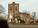 More images |
| Eastbrook public house | Dagenham | Public house | Built 1937–38 | 11 December 2009 | TQ4996585842 51°33′04″N 0°09′48″E / 51.551013°N 0.1632224°E / 51.551013; 0.1632224 (Eastbrook public house) | 1393600 |  More images |
| Fire Bell Gate, Barking Abbey | Barking | Gate | Early 19th century | 28 May 1954 | TQ4409683947 51°32′08″N 0°04′40″E / 51.535516°N 0.0778481°E / 51.535516; 0.0778481 (Fire Bell Gate, Barking Abbey) | 1064407 |  More images |
| Valence House | Becontree | House | 13th century | 28 June 1954 | TQ4804486539 51°33′28″N 0°08′09″E / 51.557785°N 0.1358266°E / 51.557785; 0.1358266 (Valence House) | 1064404 |  More images |
Grade II
| Name | Location | Type | Completed [note 1] | Date designated | Grid ref.[note 2] Geo-coordinates | Entry number [note 3] | Image |
|---|---|---|---|---|---|---|---|
| Barking station | Barking | station | 13 April 1854 | 24 November 1995 | TQ4435184373 51°32′21″N 0°04′54″E / 51.5393°N 0.0817°E / 51.5393; 0.0817 (Barking station) | 1242678 | 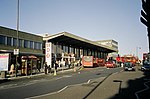 More images |
| Civic Centre | Dagenham | Building | October 1937 | 24 August 1981 | TQ4951986869 51°33′37″N 0°09′22″E / 51.5603°N 0.15615°E / 51.5603; 0.15615 (Civic Centre) | 1064422 | 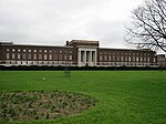 More images |
| St Patrick's Church | Barking | Church | July 1940 | 10 September 2009 | TQ4542283725 51°32′01″N 0°05′43″E / 51.5337°N 0.0952°E / 51.5337; 0.0952 (St Patrick's Church) | 1393196 |  More images |
Notes
- ^ a b c The date given is the date used by Historic England as significant for the initial building or that of an important part in the structure's description.
- ^ a b c Sometimes known as OSGB36, the grid reference is based on the British national grid reference system used by the Ordnance Survey.
- ^ a b c The "List Entry Number" is a unique number assigned to each listed building and scheduled monument by Historic England.
External links
 Media related to Grade I listed buildings in the London Borough of Barking and Dagenham at Wikimedia Commons
- Media related to Grade II* listed buildings in the London Borough of Barking and Dagenham at Wikimedia Commons
- Media related to Grade II listed buildings in the London Borough of Barking and Dagenham at Wikimedia Commons
- v
- t
- e

- Barking
- Dagenham and Rainham (part)


- Coat of arms
- Council
- Bellway Homes flats fire
- Grade I and II* listed buildings
- People
- Public art
- Schools
 Category
- Commons

Portals:
 London
 Architecture


