Fundy-St. Martins
Village municipality in New Brunswick, Canada
45°21′1.6″N 65°32′2.3″W / 45.350444°N 65.533972°W / 45.350444; -65.533972Fundy-St. Martins is a village municipality in the Canadian province of New Brunswick.[1] The jurisdiction was formed through the 2023 New Brunswick local governance reforms which saw the consolidation of entities into regions or districts.
History
Fundy-St. Martins was incorporated on January 1, 2023.[2]
Attractions
Attractions in Fundy-St. Martins include the St. Martins Sea Caves,[3] the beach and tidal harbour,[4] the start of the Fundy Trail,[5] two covered bridges and the Quaco Head Lighthouse, the Quaco Museum and Library,[6] and the Fundy Trail Parkway.[7]
Gallery
-
 St. Martins' Caves
 -
 Fundy Trail
 -
 Twin covered bridges
 -
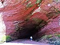 St Martins Sea Cave


See also
References
- ^ "NEW BRUNSWICK REGULATION 2022-50 under the Local Governance Act (O.C. 2022-228)". Department of Local Government and Local Government Reform, Government of New Brunswick. Retrieved February 23, 2024.
- ^ "Local Governments Establishment Regulation – Local Governance Act". Government of New Brunswick. August 30, 2022. Retrieved January 15, 2023.
- ^ "St. Martins Sea Caves". Archived from the original on September 11, 2017. Retrieved September 14, 2017.
- ^ "Tidal Harbour". Archived from the original on August 4, 2017. Retrieved September 14, 2017.
- ^ "Awe-inspiring Fundy Trail". Archived from the original on August 10, 2017. Retrieved September 14, 2017.
- ^ "Quaco Museum". Quaco Historical & Library Society. Archived from the original on September 15, 2017. Retrieved September 14, 2017.
- ^ "Fundy Trail Parkway". Retrieved September 29, 2019.
- v
- t
- e
Subdivisions of New Brunswick
- Beaurivage
- Belle-Baie
- Cap-Acadie
- Caraquet
- Carleton North
- Champdoré
- Grand Bay–Westfield
- Grand Falls
- Grand-Bouctouche
- Hampton
- Hartland
- Hautes-Terres
- Heron Bay
- Île-de-Lamèque
- Oromocto
- Quispamsis
- Riverview
- Rivière-du-Nord
- Rothesay
- Saint-Quentin
- Salisbury
- Shediac
- Shippagan
- St. Andrews
- St. Stephen
- Sussex
- Tantramar
- Vallée-des-Rivières
- Woodstock
- Acadian Peninsula
- Capital Region
- Chaleur
- Fundy
- Greater Miramichi
- Kent
- Kings
- Northwest
- Restigouche
- Southeast
- Southwest
- Western Valley
- Big Hole Tract 8 (North Half)
- Big Hole Tract 8 (South Half)
- Buctouche 16
- Buctouche Micmac Band Extension
- Devon 30
- Eel Ground 2
- Eel River 3
- Esgenoôpetitj
- Fort Folly 1
- Indian Island 28
- Indian Point 1
- Indian Ranch
- Kingsclear 6
- Metepenagiag Urban Reserve 3
- Metepenagiag Urban Reserve 8
- Metepenagiag Uta'nk
- Moose Meadows 4
- Oinpegitjoig
- Oromocto 26
- Pabineau 11
- Pokemouche 13
- Red Bank 4
- Red Bank 7
- Renous 12
- Richibucto 15
- Soegao No. 35
- St Basile 10
- St. Mary's 24
- Tabusintac 9
- The Brothers 18
- Tobique 20
- Woodstock 23
 Category:New Brunswick
 Portal:Canada
 WikiProject:New Brunswick


 | This New Brunswick location article is a stub. You can help Wikipedia by expanding it. |
- v
- t
- e


