Folden Municipality
Former municipality in Nordland, Norway
Former municipality in Nordland, Norway
Folden Municipality Folden herred | |
|---|---|
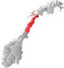 Nordland within Norway | |
 Folden within Nordland | |
| Coordinates: 67°37′26″N 15°16′45″E / 67.62389°N 15.27917°E / 67.62389; 15.27917 | |
| Country | Norway |
| County | Nordland |
| District | Salten |
| Established | 1 Jan 1838 |
| • Created as | Formannskapsdistrikt |
| Disestablished | 1 Jan 1887 |
| • Succeeded by | Nordfolden-Kjerringø Municipality and Sørfold Municipality |
| Administrative centre | Rørstad |
| Government | |
| • Mayor (1885-1886) | Lars Johnsen Wormdahl |
| Area (upon dissolution) | |
| • Total | 2,271 km2 (877 sq mi) |
| Highest elevation [1] | 1,663.6 m (5,458.0 ft) |
| Population (1887) | |
| • Total | 3,293 |
| • Density | 1.5/km2 (3.8/sq mi) |
| Demonym | Foldværing[2] |
| Time zone | UTC+01:00 (CET) |
| • Summer (DST) | UTC+02:00 (CEST) |
| ISO 3166 code | NO-1845[3] |
Data from Statistics Norway | |
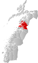
Folden is a former municipality in Nordland county, Norway. The 2,271-square-kilometre (877 sq mi) municipality[4] existed from 1838 until its dissolution in 1887. Folden encompassed all of the areas surrounding the Folda fjord and all of the fjord branches that connect to the main fjord. It included all the areas in what is now Sørfold Municipality, plus the Kjerringøy area of Bodø Municipality, and the southeastern part of the Steigen Municipality. The administrative centre was the small village of Rørstad, where the old Rørstad Church is located.[5]
General information

The municipality of Folden was established on 1 January 1838 (see formannskapsdistrikt law). The municipality existed until 1 January 1887, when it was divided into two new municipalities: Nordfolden-Kjerringø Municipality and Sørfold Municipality. Before the partition, Folden had a population of 3,293.[6]
Name
The municipality is named after the local Folda fjord (Old Norse: Fold). The name is derived from the word fold which probably means "broad" or "wide" referring to the width of the fjord. The outer part of the fjord is usually what is referred to as the Folda fjord, while the inner part of the fjord is divided into two arms Nordfolda ("the northern Folda") and Sørfolda ("the southern Folda").[7]
Churches
The Church of Norway had one parish (sokn) within Folden Municipality. At the time of the municipal dissolution, it was part of the Folden prestegjeld and the Søndre Salten prosti (deanery) in the Diocese of Sør-Hålogaland.[8]
| Parish (sokn) | Church name | Location of the church | Year built |
|---|---|---|---|
| Folden | Nordfold Church | Nordfold | 1884 |
| Kjerringøy Church | Kjerringøy | 1883 | |
| Rørstad Church | Rørstad | 1761 | |
| Røsvik Church | Røsvika | 1883 |
Geography
The municipality was quite large, stretching from the mountainous border with Sweden to the open ocean in the west. The highest point in the municipality was the 1,663.6-metre (5,458 ft) tall mountain Skagmatoppen, on the border with Sweden.[1] Steigen Municipality was to the northwest, Hamarøy Municipality was to the north, Sweden was to the east, and Fauske Municipality and Bodin Municipality were to the south.
Government
During its existence, Folden Municipality was governed by a municipal council of directly elected representatives. The mayor is indirectly elected by a vote of the municipal council.[9]
Mayors
The mayor (Norwegian: ordfører) of Folden was the political leader of the municipality and the chairperson of the municipal council. Here is a list of people who held this position:[10]
- 1838–1843: Jørgen Meyer Heffermehl
- 1843–1844: Søren Normann
- 1844–1850: Georg Taylor Faye
- 1851-1851: Gunder Enevoldsen
- 1852–1856: Torer Hemsen
- 1856–1862: Anders Andersen Alvenes
- 1863–1864: Søren Normann
- 1865–1868: Alexander Lagaard
- 1869–1872: Arent Paulsen Elenjord
- 1873–1878: Peder Benoni Larsen
- 1879–1880: Ernst Kristian Gladsjø
- 1881–1882: Petter Hansen
- 1883–1884: Henrik Normann
- 1885–1886: Lars Johnsen Wormdahl
See also
References
- ^ a b "Høgaste fjelltopp i kvar kommune" (in Norwegian). Kartverket. 2024-01-16.
- ^ "Navn på steder og personer: Innbyggjarnamn" (in Norwegian). Språkrådet.
- ^ Bolstad, Erik; Thorsnæs, Geir, eds. (2023-01-26). "Kommunenummer". Store norske leksikon (in Norwegian). Kunnskapsforlaget.
- ^ Helland, Amund (1908). "Nordfolden, Sørfolden, og Kjerringø herreder". Norges land og folk: Nordlands amt (in Norwegian). Vol. XVIII. Kristiania, Norway: H. Aschehoug & Company. p. 298. Retrieved 2018-09-15.
- ^ Thorsnæs, Geir, ed. (2016-04-23). "Folda – tidligere kommune". Store norske leksikon (in Norwegian). Kunnskapsforlaget. Retrieved 2018-09-15.
- ^ Jukvam, Dag (1999). "Historisk oversikt over endringer i kommune- og fylkesinndelingen" (PDF) (in Norwegian). Statistisk sentralbyrå. ISBN 9788253746845.
- ^ Rygh, Oluf (1905). Norske gaardnavne: Nordlands amt (in Norwegian) (16 ed.). Kristiania, Norge: W. C. Fabritius & sønners bogtrikkeri. p. 234.
- ^ Statistisk sentralbyrå (1951-01-01). Norges Sivile, Geistlige, Rettslige og Militære Inndeling 1. Januar 1951 (PDF). Norges Offisielle Statistikk (in Norwegian). Oslo, Norge: H. Aschehoug & Co.
- ^ Hansen, Tore; Vabo, Signy Irene, eds. (2022-09-20). "kommunestyre". Store norske leksikon (in Norwegian). Kunnskapsforlaget. Retrieved 2022-10-14.
- ^ Fygle, Svein (1991). Steigen bygdebok (in Norwegian). Steigen kommune. p. 286. ISBN 8274160290.
Folden Municipality at Wikipedia's sister projects:
 Definitions from Wiktionary
 Travel guides from Wikivoyage
 Data from Wikidata
- v
- t
- e
- Main article: Nordland
- Capital: Bodø
- County government: Nordland County Municipality
- County lists:

- Bodø (1816)
- Mosjøen (1875–1961, 1998)
- Narvik (1902)
- Svolvær (1918-1964, 1996)
- Mo i Rana (1923–1963, 1997)
- Brønnøysund (1923–1963, 2000)
- Sortland (1997)
- Fauske (1998)
- Sandnessjøen (1999)
- Stokmarknes (2000)
- Leknes (2002)
| Helgeland | |
|---|---|
| Lofoten | |
| Ofoten | |
| Salten | |
| Vesterålen |
|


