FK postcode area
Postcode area within the United Kingdom
56°04′41″N 3°51′36″W / 56.078°N 3.860°W / 56.078; -3.860
FK
Falkirk
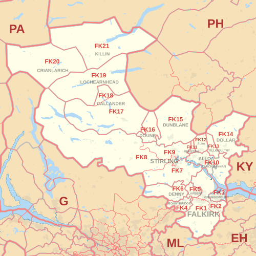
The FK postcode area, also known as the Falkirk postcode area,[2] is a group of 21 postcode districts in central Scotland, within 18 post towns. These cover most of the Falkirk council area (including Falkirk itself, Grangemouth, Larbert, Denny and Bonnybridge), most of the Stirling council area (including Stirling itself, Dunblane, Doune, Callander, Lochearnhead, Crianlarich and Killin) and Clackmannanshire (including Alloa, Clackmannan, Menstrie, Alva, Tillicoultry and Dollar), plus small parts of Fife, Perth and Kinross, and Argyll and Bute.
Coverage
The approximate coverage of the postcode districts:
| Postcode district | Post town | Coverage | Local authority area(s) |
|---|---|---|---|
| FK1 | FALKIRK | Falkirk (centre and south), Avonbridge, California, Camelon, Limerigg, Shieldhill, Slamannan, Standburn | Falkirk |
| FK2 | FALKIRK | Falkirk (north), Airth, Bainsford, Brightons, Carron, Carronshore, Dunmore, Laurieston, Maddiston, Polmont, Redding, Skinflats, Westquarter | Falkirk, Stirling |
| FK3 | GRANGEMOUTH | Grangemouth, Glensburgh | Falkirk |
| FK4 | BONNYBRIDGE | Bonnybridge, Allandale, Banknock, Dennyloanhead, Greenhill, Haggs, High Bonnybridge, Longcroft | Falkirk |
| FK5 | LARBERT | Larbert, Stenhousemuir, Torwood | Falkirk |
| FK6 | DENNY | Denny, Dunipace, Fankerton, Head of Muir, Stoneywood | Falkirk |
| FK7 | STIRLING | Stirling (south and east), Bannockburn, Cambusbarron, Cowie, Fallin, Plean, South Alloa, St. Ninians | Stirling, Falkirk |
| FK8 | STIRLING | Stirling (centre and west), Aberfoyle, Arnprior, Buchlyvie, Gargunnock, Gartmore, Inversnaid, Kippen, Port of Menteith, Ruskie, Thornhill | Stirling |
| FK9 | STIRLING | Stirling (north), Bridge of Allan, Blair Drummond, Blairlogie, Cambuskenneth, Lecropt | Stirling |
| FK10 | ALLOA | Alloa, Cambus, Kincardine, Sauchie, Tullibody | Clackmannanshire, Fife |
| CLACKMANNAN | Clackmannan, Kennet | Clackmannanshire | |
| FK11 | MENSTRIE | Menstrie | Clackmannanshire |
| FK12 | ALVA | Alva | Clackmannanshire |
| FK13 | TILLICOULTRY | Tillicoultry, Coalsnaughton, Devonside | Clackmannanshire |
| FK14 | DOLLAR | Dollar, Blairingone, Burnfoot, Glendevon, Pool of Muckhart, Solsgirth | Clackmannanshire, Perth and Kinross |
| FK15 | DUNBLANE | Dunblane, Braco, Greenloaning, Kinbuck | Stirling, Perth and Kinross |
| FK16 | DOUNE | Doune, Argaty, Buchany, Deanston | Stirling |
| FK17 | CALLANDER | Callander, Brig o' Turk, Kilmahog | Stirling |
| FK18 | CALLANDER | Ardchullarie More, Strathyre | Stirling |
| FK19 | LOCHEARNHEAD | Lochearnhead, Ardvorlich, Balquhidder, Edinample, Kingshouse | Stirling |
| FK20 | CRIANLARICH | Crianlarich, Ardchyle, Auchlyne, Luib, Tyndrum | Stirling, Argyll and Bute |
| FK21 | KILLIN | Killin, Ardeonaig, Auchmore, Clachaig, Glenlochay, Kinnell | Stirling |
Map
KML file (edit • help)
Template:Attached KML/FK postcode area
KML is from Wikidata
See also
References
- ^ "ONS Postcode Directory Version Notes" (ZIP). National Statistics Postcode Products. Office for National Statistics. May 2020. Table 2. Retrieved 19 June 2020. Coordinates from mean of unit postcode points, "Code-Point Open". OS OpenData. Ordnance Survey. February 2012. Retrieved 21 April 2012.
- ^ Royal Mail, Address Management Guide, (2004)
External links
- Royal Mail's Postcode Address File
- A quick introduction to Royal Mail's Postcode Address File (PAF)
- v
- t
- e
- AB
- AL
- B
- BA
- BB
- BD
- BH
- BL
- BN
- BR
- BS
- BT
- CA
- CB
- CF
- CH
- CM
- CO
- CR
- CT
- CV
- CW
- DA
- DD
- DE
- DG
- DH
- DL
- DN
- DT
- DY
- E
- EC
- EH
- EN
- EX
- FK
- FY
- G
- GL
- GU
- HA
- HD
- HG
- HP
- HR
- HS
- HU
- HX
- IG
- IP
- IV
- KA
- KT
- KW
- KY
- L
- LA
- LD
- LE
- LL
- LN
- LS
- LU
- M
- ME
- MK
- ML
- N
- NE
- NG
- NN
- NP
- NR
- NW
- OL
- OX
- PA
- PE
- PH
- PL
- PO
- PR
- RG
- RH
- RM
- S
- SA
- SE
- SG
- SK
- SL
- SM
- SN
- SO
- SP
- SR
- SS
- ST
- SW
- SY
- TA
- TD
- TF
- TN
- TQ
- TR
- TS
- TW
- UB
- W
- WA
- WC
- WD
- WF
- WN
- WR
- WS
- WV
- YO
- ZE
- Related UK lists: Postcode districts
- Post towns
- Postal counties
- London postal district


