Entebbe Wildlife Sanctuary
0°03′28″N 32°28′38″E / 0.057910°N 32.477290°E / 0.057910; 32.477290Area 51 square kilometres (20 sq mi) Established 1952 Governing body Uganda Wildlife Conservation Education Center National Parks Wildlife reserves Central Forest Reserves Controlled Hunting Areas Community wildlife management area Wildlife sanctuaries Ramsar Wetlands of Int'l Importance
The Entebbe Wildlife Sanctuary is found in Uganda. It was established in 1952. This site is 51 square kilometres (20 sq mi).[1]
-
 View of plant in Uganda Wildlife Conservation Education Center
 -
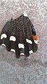 Butterfly in Uganda Wildlife Conservation Education Center
 -
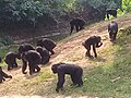 Chimpanzee meeting at the Center
 -
 Giraffe feeding at the Center


References
- ^ "Protected Planet | Entebbe". Protected Planet. Retrieved 2024-03-17.
External links
 Media related to Uganda Wildlife Conservation Education Center at Wikimedia Commons
- v
- t
- e
- Ajai
- Aswa-Lolimd
- Bokora Corridor
- Bugungu
- Kabwoya
- Karuma
- Katonga
- Kigezi
- Kyambura
- Lomunga
- East Madi
- Matheniko
- Pian Upe
- Toro-Semliki
- Buhuka
- Central Karamoja (Napak)
- North Karamoja
- South Karamoja
- Karuma Falls
- Katonga
- Lipan
- West Madi
- Sebei
- Semliki
- East Teso
- North Teso
- Amudat
- Iriri
- Kaiso Tonya
- Karenga
- Rwengara
- Entebbe
- Jinja
- Kazinga
- Malawa
- Mount Kei
- Ngama Island
- Ntoroko-Kanara
- Nyaburogo
- Otze Forest
- UWEC
- Ziwa Rhino
- Lake Bisina
- Lake George
- Lake Mburo-Nakivali
- Lake Nabugabo
- Lake Nakuwa
- Lake Opeta
- Lutembe Bay
- Mabamba Bay
- Murchison Falls
- Nabajjuzi
- Rwenzori Mountains
- Sango Bay-Musambwa Island-Kagera Bay
- Uganda Wildlife Authority
- National Environment Management Authority
- d indicates degazetted
 | This Uganda location article is a stub. You can help Wikipedia by expanding it. |
- v
- t
- e


