Dorkwerd
Village in Groningen, Netherlands
53°15′2″N 6°30′45″E / 53.25056°N 6.51250°E / 53.25056; 6.51250 (2021)[1]
9746[1]
Dorkwerd is a small village in Groningen, the Netherlands. It is located in the municipality of Groningen, about 4 km northwest of the city center.[3] Recent construction of new residential areas have brought the city to less than 500 meters from the village of Dorkwerd, and the postal authorities have placed it under Groningen.[4][5]
According to the 19th-century historian A.J. van der Aa,[6] Dorkwerd (also written Dorkwert, Dorquert) consisted of 19 houses, with a population of almost 140. Most of the village was in the municipality of Hoogkerk, west of the Reitdiep canal, but two houses belonging to the village were east of the canal in Adorp. There was a small village school here, built in 1832.
History
The village was first mentioned in 1335 as Dorquerth, and means terp probably in combination with dregs (sediment settled in the water).[7] Dorkwerd was built on a terp (artificial living hill). The church is in the centre. It was built in 1648 as a replacement of a church which could have been from around 1200. In 1869, a tower was added.[5]
Dorkwerk was home to 111 people in 1840.[5] Most of the terp around the church has been excavated around 1911.[7][5] The excavation caused the church to subside, and in 2009, the foundation of the church was strengthened.[5]
Gallery
-
 Former school master's house
 -
 Village house
 -
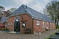
 Pub Onder de Linden
 -
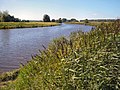 Rietdiep near Dorkwerd


References
- ^ a b c "Kerncijfers wijken en buurten 2021". Central Bureau of Statistics. Retrieved 8 April 2022.
- ^ "Postcodetool for 9746AA". Actueel Hoogtebestand Nederland (in Dutch). Het Waterschapshuis. Retrieved 8 April 2022.
- ^ ANWB Topografische Atlas Nederland, Topografische Dienst and ANWB, 2005.
- ^ "Postcode 9746 in Groningen". Postcode bij adres (in Dutch). Retrieved 8 April 2022.
- ^ a b c d e "Dorkwerd". Plaatsengids (in Dutch). Retrieved 8 April 2022.
- ^ Abraham Jacob van der Aa, "Aardrijkskundig woordenboek der Nederlanden", vol. 3 (C/D), 1841.
- ^ a b "Dorkwerd - (geografische naam)". Etymologiebank (in Dutch). Retrieved 8 April 2022.
External links
 Media related to Dorkwerd at Wikimedia Commons
- v
- t
- e
Populated places in the municipality of Groningen
- Groningen
- Haren
- Hoogkerk
- Dorkwerd
- Engelbert
- Garmerwolde
- Glimmen
- Leegkerk [nl]
- Lellens [nl]
- Meerstad
- Middelbert [nl]
- Noorddijk
- Noorderhoogebrug
- Noordlaren
- Onnen
- Paterswolde (partially)
- Sint-Annen [nl]
- Ten Boer
- Ten Post
- Thesinge
- Winneweer
- Wittewierum [nl]
- Woltersum [nl]
- Essen
- Ruischerbrug [nl]
 | This Groningen location article is a stub. You can help Wikipedia by expanding it. |
- v
- t
- e


