Coppetts Wood and Scrublands
Nature reserve in the London Borough of Barnet

Coppetts Wood and Scrublands is a 14.5-hectare (36-acre) Site of Borough Importance for Nature Conservation, Grade I, between Muswell Hill and Friern Barnet in the London Borough of Barnet.[1][2] It is part of the Coppetts Wood and Glebelands Local Nature Reserve.[3][4]
The main trees are oak and hornbeam, and ground flora include bluebell and garlic mustard. Breeding birds include woodpeckers, tawny owls and sparrowhawks. A small pond has a clump of yellow iris, and common frogs and smooth newts. Scrublands has a variety of habitats and some rare plants such as imperforate St John's-wort. There are several rare species of insects.[1]
Coppetts Wood was once part of a forest known as Finchley Wood. By the sixteenth century it had shrunk in size and became known as a common, and in the seventeenth and eighteenth centuries it was used for pursuits such as bare-knuckle boxing, horse racing and pigeon shooting. It also had a reputation as a haunt of highwaymen. In the nineteenth century a sewage works was built on the site. It was closed in 1963, but still has its legacy in the rich variety of plants in the Scrublands. In the Second World War it was used for military training, and several tank traps still remain.[5]
Access to the site is from Colney Hatch Lane and North Circular Road.
The Coppetts Wood Conservationists meet on Sunday mornings throughout the year with the aim of maintaining the nature reserve, increasing its biodiversity and enjoying some sociable exercise.[6]
Coppetts is also a ward of the London Borough of Barnet. At 2011 Census the ward population was 17,250.[7]
Gallery
-
 Coppetts Wood path
 -
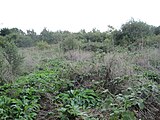 Scrublands
 -
 Pond at Coppetts Wood


See also
References
- ^ a b "Coppett's Wood and Scrubland LNR". Greenspace Information for Greater London. 2006. Archived from the original on 24 December 2012. Retrieved 6 September 2012.
- ^ "iGiGL – helping you find London's parks and wildlife sites". Greenspace Information for Greater London. 2006. Archived from the original on 2012-10-15.
- ^ "Coppetts Wood and Glebelands". Local Nature Reserves. Natural England. 4 March 2013. Archived from the original on 2 February 2014. Retrieved 22 January 2014.
- ^ "Map of Coppetts Wood and Glebelands". Local Nature Reserves. Natural England. Retrieved 22 January 2014.
- ^ Coppett's Wood noticeboard
- ^ "Coppetts Wood Conservationists". Archived from the original on 2015-08-01. Retrieved 2017-03-24.
- ^ "Barnet Ward population 2011". Neighbourhood Statistics. Office for National Statistics. Retrieved 19 October 2016.
External links
- Coppett's Wood and Scrublands Local Nature Reserve, London Gardens Online
- Coppetts Wood and Glebelands LNR website This also covers the neighbouring Glebelands Local Nature Reserve.
- Coppetts Wood on the Woodland Trust website
- Coppetts Wood Conservationists
Further reading
- Hewlett, Janet (1997). Nature Conservation in Barnet. London Ecology Unit. ISBN 1 871045 27 4.
- v
- t
- e
- Arkley Lane and Pastures
- Arkley South Fields
- Arrandene Open Space and Featherstone Hill
- Ashley Lane
- Avenue House Grounds
- Barfield Allotments Nature Park
- Barnet Countryside Centre
- Barnet Gate Wood
- Bell's Hill Burial Ground
- Belmont Open Space
- Big Wood and Little Wood
- Brent Park
- Brent Reservoir (Welsh Harp)
- Bruno's Field
- Burnt Oak Brook
- Burtonhole Lane and Pasture
- Cherry Tree Wood
- Clarefield Park
- Clay Lane
- Clitterhouse Recreation Ground
- College Farm
- Coppett's Wood and Scrublands
- Copthall Railway Walk and Copthall Old Common
- Copthall South Fields
- Darland's Lake
- Deans Brook
- Dollis Brook
- Drivers Hill
- East Finchley Cemetery
- Edgware Way Rough
- Edgwarebury Brook
- Edgwarebury Park
- Folly Brook
- Friary Park
- Glebe Lane Pastures
- Glebelands Local Nature Reserve
- Golders Hill Park
- Greenhill Gardens
- Hadley Green
- Hampstead Heath Extension
- Hendon Churchyard
- Hendon Park and Northern Line Railway Cutting
- King George's Fields
- Lakeside Nature Reserve
- Mill Hill Golf Course
- Mill Hill Old Railway Nature Reserve
- Mill Hill Substation Pastures
- Moat Mount
- Monken Hadley Common
- Mutton Brook
- New Southgate Cemetery
- North Middlesex Golf Course Ponds
- Northern Line Embankment, High Barnet
- Oak Hill Wood
- Oakleigh Park Rail Cutting
- Princes Park
- Pymme's Brook
- River Brent
- Rowley Green Common
- Rowley Lodge Field
- Scratchwood
- Silk Stream
- St Pancras and Islington Cemetery
- Stoneyfields Park
- Sulloniacis Pastures
- Sunny Hill Park
- The Mill Field
- Totteridge Common
- Totteridge Croft Field
- Totteridge Fields
- Totteridge Green
- Turner's Wood
- Woodridge Nature Reserve
51°36′31″N 0°09′27″W / 51.6087°N 0.1574°W / 51.6087; -0.1574


