Bow River pathway
The Bow River pathway is a pathway system developed along the banks of the Bow River in the city of Calgary. It contains a network of pedestrian and bicycle paths connecting parks on both sides of the river.


The pathway is used for cycling, hiking, jogging, as well as rollerblading and skateboarding. The paths are connected with a system that extends along the Elbow River and other areas of the city.
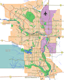
The network spans 48 kilometres (30 mi) from Bearspaw Dam to Fish Creek Provincial Park, connecting major parks and green areas in Calgary.
Construction of the Bow River Pathways started in 1975 to mark the city's centenary. The project was funded by the City of Calgary, the Province of Alberta and the Devonian Group of Charitable Foundations. It was dedicated on June 25, 1977.
Recreation areas
Recreation areas connected by the pathway include:
| Recreation area | Type | Location | Remarks |
|---|---|---|---|
| Valley Ridge Golf Course | Golf Course | Right bank 51°06′02″N 114°14′11″W / 51.10067°N 114.23650°W / 51.10067; -114.23650 (Valley Ridge Golf Course) | |
| Bowness Park | City park | right bank 51°05′53″N 114°13′12″W / 51.09810°N 114.22005°W / 51.09810; -114.22005 (Bownsess Park) | |
| Baker Park | City park | left bank 51°06′03″N 114°13′16″W / 51.10080°N 114.22101°W / 51.10080; -114.22101 (Baker Park) | |
| Bowmont Natural Area | Natural area | left bank 51°05′33″N 114°10′52″W / 51.092430°N 114.181093°W / 51.092430; -114.181093 (Bowmont Natural Area) | |
| Shouldice Park | City park | left bank 51°04′21″N 114°10′21″W / 51.07259°N 114.17254°W / 51.07259; -114.17254 (Shouldice Park) | |
| Edworthy Park | City park | right bank 51°03′44″N 114°09′30″W / 51.06236°N 114.15829°W / 51.06236; -114.15829 (Edworthy Park) | |
| Shaganappi Point Golf Course | Golf Course | right bank 51°02′44″N 114°07′36″W / 51.04546°N 114.12670°W / 51.04546; -114.12670 (Shaganappi Point Golf Course) | |
| Broadview Park | City park | left bank 51°02′59″N 114°06′25″W / 51.04985°N 114.10706°W / 51.04985; -114.10706 (Broadview Park) | |
| Shaw Millennium Park | Skatepark | right bank 51°02′46″N 114°05′32″W / 51.04601°N 114.09211°W / 51.04601; -114.09211 (Millennium Park) | |
| Eau Claire Park | City park | right bank 51°03′08″N 114°04′50″W / 51.05209°N 114.08045°W / 51.05209; -114.08045 (Eau Claire Park) | |
| Prince's Island Park | City park | on Prince's Island 51°03′21″N 114°04′13″W / 51.05573°N 114.07017°W / 51.05573; -114.07017 (Prince's Island Park) | |
| Sunnyside Park | City park | left bank 51°03′30″N 114°04′03″W / 51.05823°N 114.06748°W / 51.05823; -114.06748 (Sunnyside Park) | in south-east Sunnyside |
| Sien Lok Park | City park | right bank 51°03′12″N 114°03′55″W / 51.05328°N 114.06518°W / 51.05328; -114.06518 (Sien Lok Park) | part of Chinatown |
| Bow River Park | City park | left bank 51°03′15″N 114°03′41″W / 51.05420°N 114.06152°W / 51.05420; -114.06152 (Bow River Park) | |
| Fort Calgary | Historic park, museum | right bank 51°02′43″N 114°02′44″W / 51.04536°N 114.04553°W / 51.04536; -114.04553 (Fort Calgary) | part of East Village, connects with Elbow River pathway |
| Calgary Zoo | Zoo | on St George's Island 51°02′43″N 114°02′03″W / 51.04540°N 114.03409°W / 51.04540; -114.03409 (Calgary Zoo) | Zoo extends on left bank |
| Pearce Estate Wetland | City park, nature reserve | right bank 51°02′28″N 114°00′51″W / 51.04121°N 114.01413°W / 51.04121; -114.01413 (Pearce Estate Wetland) | |
| Inglewood Golf and Country Club | Golf Course | left bank 51°02′01″N 114°00′13″W / 51.03360°N 114.00369°W / 51.03360; -114.00369 (Inglewood Golf and Country Club) | |
| Inglewood Bird Sanctuary | Nature reserve | right bank 51°01′41″N 114°00′24″W / 51.02807°N 114.00668°W / 51.02807; -114.00668 (Inglewood Bird Sanctuary) | Access to Bow Habitat Station, Inglewood Wildlands Park, and the Sam Livingston Fish Hatchery |
| Old Refinery Park | City park | left bank 51°00′20″N 114°01′02″W / 51.00568°N 114.01712°W / 51.00568; -114.01712 (Old Refinery Park) | |
| Southland Park | City park | left bank 50°58′30″N 114°02′00″W / 50.97493°N 114.03332°W / 50.97493; -114.03332 (Southland Park) | |
| Carburn Park | City park | left bank 50°58′28″N 114°01′58″W / 50.974538°N 114.032740°W / 50.974538; -114.032740 (Carburn Park) | |
| Douglasbank Park | City park | left bank 50°56′30″N 114°00′36″W / 50.94173°N 114.01006°W / 50.94173; -114.01006 (Douglasbank Park) | |
| Fish Creek Provincial Park | Provincial park | right bank 50°54′33″N 114°00′45″W / 50.90909°N 114.01252°W / 50.90909; -114.01252 (Fish Creek Provincial Park) | |
| McKenzie Meadows Golf Club | Golf course | left bank 50°54′22″N 114°00′17″W / 50.90614°N 114.00469°W / 50.90614; -114.00469 (McKenzie Meadows Golf Club) | |
| Sikome Lake | Man-made lake | right bank 50°53′52″N 114°00′57″W / 50.89784°N 114.01574°W / 50.89784; -114.01574 (Sikome Lake) |
Map all coordinates using OpenStreetMap
Download coordinates as:
- KML
- GPX (all coordinates)
- GPX (primary coordinates)
- GPX (secondary coordinates)
See also
References
External links
- City of Calgary. Pathways and Bikeways
- v
- t
- e
- Plus 15
- Baitun Nur
- Bridges
- Brookfield Place
- Burns Building
- Calgary Central Library
- Calgary City Hall
- Calgary Tower
- Centre Street Bridge
- Fairmont Palliser
- Hart House
- Mewata Armouries
- Stephen Avenue
- Tallest buildings
- Telus Sky
- The Bow
- Battalion
- Bowness
- Central Memorial
- Confederation
- Devonian Gardens
- Edworthy
- Fish Creek
- Millennium
- Nose Hill
- Olympic Plaza
- Peacekeeper
- Pearce Estate
- Prince's Island
 Canada portal
- Italics indicate a landmark / location outside of the City of Calgary; the character * indicates a landmark / location under construction.


