Blumine Island
41°10′29″S 174°14′22″E / 41.1748°S 174.2395°E / -41.1748; 174.2395
New Zealand
Blumine Island / Ōruawairua[1] is an island in the outer reaches of Queen Charlotte Sound / Tōtaranui, in the Marlborough Sounds at the northern end of New Zealand's South Island.
The New Zealand Ministry for Culture and Heritage gives a translation of "meeting place of spirits" for Ōruawairua.[2]
Description
Blumine Island covers 377 ha (930 acres)[3] and is mostly hill country. The island is located about 22 kilometres (14 mi) north of Picton.[4] It is the site of a scenic reserve meaning anyone can visit the island. A visit by Captain James Cook left the island infested with introduced pests, which have since been eradicated through the use of helicopter poison drops, conducted by the Department of Conservation. In May 2008 the island was declared predator free and efforts began to reintroduce native species back to the island.[5]
During World War II, two gun emplacements were built on the island by soldiers and workmen from the Public Works Department. This was to protect a planned American Navy anchorage in the Marlborough Sounds from a feared Japanese invasion. The sites were abandoned in 1945 towards the end of the war. In 2012, walking tracks were built, connecting the island's main campsite with the emplacements.[4]
Blumine Island hosts Outward Bound and Untouched World Charitable Trust who help in the maintenance of the island.
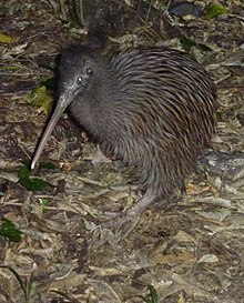
Kiwi
On 29 June 2010, three pairs of the rarest kiwi, rowi kiwi were released onto the island.[6]
See also
 Islands portal

- List of islands of New Zealand
- List of islands
- Desert island
References
- ^ "Blumine Island / Ōruawairua". gazetteer.linz.govt.nz. Retrieved 25 January 2022.
- ^ "1000 Māori place names". New Zealand Ministry for Culture and Heritage. 6 August 2019.
- ^ "Data Table - Protected Areas - LINZ Data Service (recorded area 376.732 ha)". Land Information New Zealand. Retrieved 30 August 2019.
- ^ a b Nicoll, Jared (7 July 2012). "Former fort a refuge for endangered species". The Press. Christchurch. p. A17.
- ^ "Island sanctuaries in the Marlborourgh Sounds" (PDF). Publications. Department of Conservation.
- ^ "Kiwi released on Blumine Island". The Marlborough Express. 30 June 2010. Retrieved 21 September 2011.
- v
- t
- e
Marlborough District, New Zealand
Seat: Blenheim
| Marlborough Sounds | |
|---|---|
| Blenheim | |
| Wairau-Awatere |
| Islands |
|
|---|---|
| Bodies of water |
|
| Landforms |
|
41°10′29″S 174°14′22″E / 41.1748°S 174.2395°E / -41.1748; 174.2395
 | This Marlborough Region-related geography article is a stub. You can help Wikipedia by expanding it. |
- v
- t
- e


