Benito Juárez National Park
National park in Oaxaca, Mexico
17°10′05″N 96°44′20″W / 17.16806°N 96.73889°W / 17.16806; -96.73889
The Benito Juárez National Park is in the Valles Centrales Region of Oaxaca, Mexico, and includes parts of the municipalities of San Felipe Tejalapam and San Andres Huayapan. The southern boundary of the park is about five kilometers north of the City of Oaxaca. The park was established in 1937 during the presidency of General Lazaro Cardenas del Rio, and is named after President Benito Juárez, who was a native of Oaxaca.[1]
Description
The park ranges from 1,650 to 3,050 meters above sea level. The climate is Coastal sub-humid and Temperate sub-humid. The main rivers that cross the park are the Huayapan and San Felipe rivers. Most of their water is piped to supply the city of Oaxaca.[2] The park covers 2,737 hectares, including the 3,111 meter high Cerro San Felipe, part of the Sierra Madre de Oaxaca.[1] There are pine and oak forests in the upper reaches of the mountain. Lower down there are scrub oaks, and tropical deciduous forest in the canyons.
Concerns
The park is the main home of the dwarf jay (Cyanolyca nana), considered a vulnerable species. The boundaries of the park are not well delimited.[3] The park is threatened by livestock encroachment, illegal logging, forest fires and hunting. The pine-oak forests are being attacked by mistletoe, especially in the area adjacent to San Andrés Huayapan.[2] The sport of downhill cycling is popular within the park.[4]
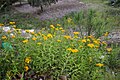
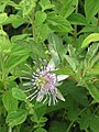
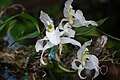
Gallery of flora
-
 Rhynchostele cervantesii ssp. membranacea an endemic orchid in Oaxaca
 -
 Dalia, national flower of Mexico
 -
 Orquídea de Tierra (Govenia lilacea)
 -
 Pericón (Tagetes lucida)
 -
 Pinguicula stolonifera, carnivorous plant
 -
 Another species of Pinguicula (Pinguicula moranensis)
 -
 Passiflora (Passiflora holosericea)
 -
 Rhynchostele galeottiana a species of orchid in danger of extinction


References
Wikimedia Commons has media related to Benito Juárez National Park.
- ^ a b "National Park "Benito Juárez"". Oaxaca's Tourist Guide. Archived from the original on 2011-07-14. Retrieved 2010-07-13.
- ^ a b "Benito Juarez National Park". PLANETA.COM. Archived from the original on 2010-04-28. Retrieved 2010-07-13.
- ^ "Dwarf Jay Cyanolyca nana". BirdLife International. Retrieved 2010-07-13.
- ^ "Oaxaca de Juarez Travel Information". Traverse America. Retrieved 2010-07-13.
- v
- t
- e
- Archipiélago Espíritu Santo
- Arrecife Alacranes
- Arrecife de Puerto Morelos
- Arrecifes de Cozumel
- Arrecifes de Xcalak
- Bahía de Loreto
- Barranca del Cupatitzio
- Basaseachic Falls
- Benito Juárez
- Bosencheve
- Cabo Pulmo
- Cañón del Río Blanco
- Cañón del Sumidero
- Cerro de Garnica
- Cerro de la Estrella
- Cerro de Las Campanas
- Cofre de Perote
- Constitution 1857
- Costa Occidental de Isla Mujeres
- Cumbres de Majalca
- Cumbres de Monterrey
- Cumbres del Ajusco
- Desierto de los Leones
- Desierto del Carmen
- Dzibilchantun
- El Cimatario
- El Gogorrón
- El Histórico Coyoacán
- El Potosí
- El Sabinal
- El Tepeyac
- El Tepozteco
- El Veladero
- Fuentes Brotantes de Tlalpan
- General Juan N. Álvarez
- Grutas de Cacahuamilpa
- Huatulco
- Insurgente José María Morelos y Pavón
- Insurgente Miguel Hidalgo y Costilla (La Marquesa)
- Isla Contoy
- Isla Isabel
- Islas Marietas
- Iztaccíhuatl–Popocatépetl
- La Malinche (Matlalcuéyatl)
- Lago de Camécuaro
- Lagunas de Chacahua
- Lagunas de Montebello
- Lagunas de Zempoala
- Lomas de Padierna
- Los Mármoles
- Los Novillos
- Los Remedios
- Mineral del Chico
- Molino de Flores Nezahualcóyotl
- Nevado de Toluca
- Palenque
- Pico de Orizaba
- Rayon
- Sacromonte
- San Lorenzo Marine Archipelago
- Sierra de San Pedro Mártir
- Sierra de Órganos
- Tula
- Tulum
- Veracruz Reef System
- Volcán Nevado de Colima
- Xicoténcatl


