Batts Combe quarry
Limestone quarry in Somerset, England
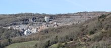
Batts Combe quarry, grid reference ST460550 is a limestone quarry on the edge of Cheddar village on the Mendip Hills, Somerset, England.
It has been operating since the early 20th century and is currently owned and operated by Singleton Birch Ltd. The output in 2005 was around 4,000 tonnes of limestone per day, one third of which was supplied to an on-site lime kiln, the remainder being sold as coated or dusted aggregates. The limestone at this site is close to 99% carbonate of calcium and magnesium (dolomite).[1] In former years it was a major supplier of limestone for railway track ballast purposes.
A lime-burning kiln at the site was closed for a while in 2006 after testing showed quicklime dust was escaping into the atmosphere. The kiln, which produced 200,000 tonnes of quicklime a year for use in the steel industry, required £300,000 of investment to resolve the problems. The closure followed an earlier warning from the Environment Agency when the company was notified that it should tighten up procedures at the site. Quicklime dust is a health hazard, which in large quantities can cause skin irritation and damage to the eyes and throat.[2] In March 2009 however the lime kiln closed, supposedly indefinitely, following a drop in demand from the site's sole customer, Corus.;[3] the quarry has since been taken over by Melton Ross, Lincolnshire-based Singleton Birch.
There is some evidence of a Bronze Age field system at the site.[4] Boxes were placed in Hanson woodland adjoining the company's Batts Combe quarry to encourage dormice to breed, and monitored with the help of pupils from Wells Cathedral School.
See also
References
- ^ Atthill, Robin (1976). Mendip: A new study. Newton Abbott: David & Charles. ISBN 0-7153-7297-1.
- ^ "Quarry kiln closed over dust fears". Minerals UK. Retrieved 11 February 2007.
- ^ "Jobs may go as kiln is closed". Cheddar Valley Gazette. 26 March 2009. Archived from the original on 21 April 2013. Retrieved 29 March 2009.
- ^ "Mendip Hills: An Archaeological Survey of the Area of Outstanding Natural Beauty" (PDF). Somerset County Council. Archived (PDF) from the original on 6 February 2007. Retrieved 11 February 2007.
External links
- Data for this mine at mindat.org
- v
- t
- e
Mendip Hills
- Ashwick
- Axbridge
- Banwell
- Bishop Sutton
- Blagdon
- Bleadon
- Burrington
- Charterhouse
- Cheddar
- Chewton Mendip
- Churchill
- Compton Bishop
- Compton Martin
- Cross
- Draycott
- East Harptree
- Easton
- Hinton Blewett
- Hutton
- Leigh-on-Mendip
- Litton
- Oakhill
- Priddy
- Rodney Stoke
- Rowberrow
- Sandford
- Shepton Mallet
- Shipham
- Ubley
- Webbington
- Wells
- West Harptree
- Westbury-sub-Mendip
- Winscombe
- Wookey Hole
- Attborough Swallet
- Aveline's Hole
- Axbridge Ochre Mine
- Banwell Caves
- Banwell Ochre Caves
- Burrington Combe
- Charterhouse Cave
- Cheddar Gorge
- Compton Martin Ochre Mine
- Cox's Cave
- Eastwater Cavern
- Ebbor Gorge
- Fairy Cave Quarry
- GB Cave
- Goatchurch Cavern
- Gough's Cave
- Hunter's Hole
- Lamb Leer
- Longwood Swallet
- Manor Farm Swallet
- Picken's Hole
- Pierre's Pot
- Priddy Caves
- Read's Cavern
- Reservoir Hole
- Rhino Rift
- Rod's Pot
- Shatter Cave
- Shute Shelve Cavern
- Sidcot Swallet
- St Cuthbert's Swallet
- St. Dunstan's Well Catchment
- Stoke Lane Slocker
- Swildon's Hole
- Thrupe Lane Swallet
- Tyning's Barrow Swallet
- Upper Flood Swallet
- W/L Cave
- Wookey Hole Caves
- Asham Wood
- Axbridge Hill and Fry's Hill
- Banwell Caves
- Banwell Ochre Caves
- Barns Batch Spinney
- Blagdon Lake
- Bleadon Hill
- Brimble Pit and Cross Swallet Basins
- Burledge Hill
- Burrington Combe
- Chancellor's Farm
- Cheddar Complex
- Cheddar Reservoir
- Cheddar Wood
- Chew Valley Lake
- Cloford Quarry
- Compton Martin Ochre Mine
- Cook's Wood Quarry
- Crook Peak to Shute Shelve Hill
- Dolebury Warren
- Draycott Sleights
- Ebbor Gorge
- Emborough Quarries
- Harptree Combe
- Hobbs Quarry
- Holwell Quarries
- Kingdown and Middledown
- Lamb Leer
- Priddy Caves
- Priddy Pools
- Perch
- Rodney Stoke
- St. Dunstan's Well Catchment
- Sandpit Hole and Bishop's Lot
- Shiplate Slait
- Viaduct Quarry
- Windsor Hill Quarry
- Wurt Pit and Devil's Punchbowl
51°17′31″N 2°46′41″W / 51.292°N 2.778°W / 51.292; -2.778


