Arzay
Part of Porte-des-Bonnevaux in Auvergne-Rhône-Alpes, France
Location of Arzay

45°25′35″N 5°10′16″E / 45.4264°N 5.1711°E / 45.4264; 5.1711
1
(2019)[1]
38260
Arzay (French pronunciation: [aʁzɛ]) is a former commune in the Isère department in the Auvergne-Rhône-Alpes region of south-eastern France. On 1 January 2019, it was merged into the new commune Porte-des-Bonnevaux.[2]
Geography
Arzay is located some 27 km east by south-east of Vienne and 25 km south of Villefontaine. Access to the commune is by the minor D51 road (Route de Beaurepaire) from Pommier-de-Beaurepaire in the south-west passing through the heart of the commune south of the village and continuing to Semons in the east. Access to the village can be by several country roads running off the D51 including the Chemin de la Grande Fontaine, the Chemin de la Croix, or the Chemin de la Diligence. The hilly part of the commune north of the village is heavily forested (part of the Forest of Bonnevaux) while the flat commune south of the village is farmland.[3]
A band of "Étangs" - ponds or lakes - crosses the commune in the north from south-west to north-east. The Étangs within the commune are:
- Étang du Grand Albert,
- Étang Girand,
- Étang Coquet,
- Étang du Grand Massot,
- Étang Girond,
- Étang du Petit Massot,
- Étang de Clos Gabet,
- Étang de la Chapelle,
- Étang Ras,
- Étang Tournier.
The Suzon river [fr] flows through the south of the commune from east to west and continues south-west to eventually join the Oron at Beaurepaire. The Grande Vareze flows into the largest of the Étangs in the north - the Étang du Grand Albert.[3]
Neighbouring communes and villages
Places adjacent to Arzay | |
|---|---|


[3]
Administration

This list is incomplete; you can help by adding missing items. (April 2021) |
List of Successive Mayors[4]
| From | To | Name |
|---|---|---|
| 2002 | Jean Chabert | |
| 2002 | 2008 | Nicole Reverchon |
| 2008 | 2014 | Élizabeth Virenque |
| 2014 | 2019 | Liliane Térol |
Demography
The inhabitants of the commune are known as Arzayaux in French.[5]
|
| |||||||||||||||||||||||||||||||||||||||||||||||||||||||||||||||||||||||||||||||||||||||||||||||||||||||||||||||
| ||||||||||||||||||||||||||||||||||||||||||||||||||||||||||||||||||||||||||||||||||||||||||||||||||||||||||||||||
| Source: EHESS[6] and INSEE[7] | ||||||||||||||||||||||||||||||||||||||||||||||||||||||||||||||||||||||||||||||||||||||||||||||||||||||||||||||||


Sites and monuments


- The Chateau d'Arzay from the 19th century (chapel)
- A Bread oven in the Place Jean Chabert (next to the church)
- Numerous Étangs with the Étang du Grand Albert the most well known (private access)
Church Picture Gallery
-
 Arzay Church
 -
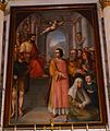 A Painting in the Church
 -
 Stained Glass
 -
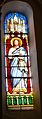
 Stained Glass - Saint Joseph
 -
 Stained Glass
 -
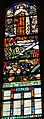 Stained Glass - 2nd World War
 -
 Stained Glass - Saint Hubert


Life in the commune
- A Bread Festival in the last Sunday of August
Notable people linked to the commune
- The Chambaran family, gentleman glassmakers of Arzay, allied to the great Daupinois families in the 17th century.
See also
References
- ^ Téléchargement du fichier d'ensemble des populations légales en 2019, INSEE
- ^ Arrêté préfectoral 12 November 2018 (in French)
- ^ a b c Google Maps
- ^ List of Mayors of France (in French)
- ^ Le nom des habitants du 38 - Isère, habitants.fr
- ^ Des villages de Cassini aux communes d'aujourd'hui: Commune data sheet Arzay, EHESS (in French).
- ^ Populations légales 2012, INSEE
External links
- Arzay on the 1750 Cassini Map
Wikimedia Commons has media related to Arzay.
| Authority control databases: National |
|
|---|


