Acy, Louisiana
Unincorporated community in Louisiana, United States
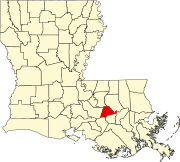
30°13′08″N 90°49′13″W / 30.21889°N 90.82028°W / 30.21889; -90.82028Acy is an unincorporated community in the southeastern part of Louisiana, United States.[1] Acy is located approximately 24 miles (39 km) southeast of Baton Rouge and 45 miles (72 km) northwest of New Orleans on Louisiana Highway 22 in the parish of Ascension.[2] The residents live along highways LA22, LA936, LA937, and many short parish side roads mostly named after current or past residents of the area. Acy consists of woodlands and pastures. Acy is a rural area located off a ridge surrounded by swamp lands. Its area is six miles (9.7 km) long and about one mile (1.6 km) wide.
References
- v
- t
- e
Municipalities and communities of Ascension Parish, Louisiana, United States
Parish seat: Donaldsonville
- Donaldsonville
- Gonzales
unincorporated
communities
- Aben
- Acy
- Belle Helene
- Brittany
- Burnside
- Duplessis
- Dutchtown
- Galvez
- Geismar
- Hillaryville
- Hobart
- Lake
- Little Prairie
- Marchand
- Modeste
- St. Amant
- Smoke Bend
‡This populated place also has portions in an adjacent parish or parishes
- Louisiana portal
- United States portal
Authority control databases | |
|---|---|
| International |
|
| National |
|
 | This Louisiana state location article is a stub. You can help Wikipedia by expanding it. |
- v
- t
- e


