Đất Đỏ district
District in South East, Vietnam
Đất Đỏ district Huyện Đất Đỏ | |
|---|---|
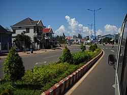 Đất Đỏ town in Đất Đỏ District | |
| Country |  Vietnam Vietnam |
| Region | South East |
| Province | Bà Rịa–Vũng Tàu |
| Capital | Thị trấn Đất Đỏ |
| Area | |
| • Total | 70 sq mi (190 km2) |
| Population (2019 census) | |
| • Total | 73,530 |
| • Density | 1,000/sq mi (390/km2) |
| Time zone | UTC+7 (Indochina Time) |
Đất Đỏ is a rural district of Bà Rịa–Vũng Tàu province in the Southeast region of Vietnam. As of 2019, the district had a population of 73,530.[1][2] The district covers an area of 190 km². The district capital lies at Phước Hải.[2]
This district is the home area of the prominent communist Võ Thị Sáu.
Administrative divisions
The district is divided administratively into 2 townships: Đất Đỏ, the capital, and Phước Hải. Đất Đỏ contains the following wards: Phước Long Thọ, Long Tân, Láng Dài, Lộc An, Phước Hội and Long Mỹ.
References
- ^ "Vietnam: Administrative Division (Provinces and Districts) - Population Statistics, Charts and Map". www.citypopulation.de. Retrieved 2024-02-07.
- ^ a b "Districts of Vietnam". Statoids. Retrieved March 13, 2009.
- v
- t
- e
Districts of Southeast Vietnam
- Municipal city
- Urban districts
- Rural districts

- Dĩ An city
- Thuận An city
- Thủ Dầu Một city※
- Bến Cát city
- Tân Uyên city
- Bắc Tân Uyên
- Bàu Bàng
- Dầu Tiếng
- Phú Giáo
- Đồng Xoài city※
- Bình Long town
- Chơn Thành town
- Phước Long town
- Bù Đăng
- Bù Đốp
- Bù Gia Mập
- Đồng Phú
- Hớn Quản
- Lộc Ninh
- Phú Riềng
- Tây Ninh city※
- Hòa Thành town
- Trảng Bàng town
- Bến Cầu
- Châu Thành
- Dương Minh Châu
- Gò Dầu
- Tân Biên
- Tân Châu
※ denotes provincial seat
10°28′40″N 107°18′27″E / 10.47778°N 107.30750°E / 10.47778; 107.30750
 | This article about a location in Bà Rịa-Vũng Tàu province, Vietnam is a stub. You can help Wikipedia by expanding it. |
- v
- t
- e


