Wells County (Indiana)
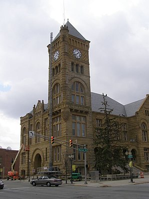 Wells County Courthouse, gelistet im NRHP | |
| Verwaltung | |
|---|---|
| US-Bundesstaat: | Indiana |
| Verwaltungssitz: | Bluffton |
| Gründung: | 1837 |
| Demographie | |
| Einwohner: | 28.180 (Stand: 2020) |
| Bevölkerungsdichte: | 29,42 Einwohner/km2 |
| Geographie | |
| Fläche gesamt: | 959 km² |
| Wasserfläche: | 1 km² |
| Karte | |
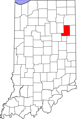 | |
Wells County[1] ist ein County im Bundesstaat Indiana der Vereinigten Staaten. Der Verwaltungssitz (County Seat) ist Bluffton.
Geographie
Die Nachbar-Countys (im Norden startend, im Uhrzeigersinn) sind: Allen County, Adams County, Jay County, Blackford County, Grant County und Huntington County.
Geschichte
4 Bauwerke und Stätten des Countys sind im National Register of Historic Places eingetragen (Stand 5. September 2017).[2]
Bevölkerungsentwicklung
| Bevölkerungsentwicklung | |||
|---|---|---|---|
| Census | Einwohner | ± rel. | |
| 1840 | 1.822 | — | |
| 1850 | 6.152 | 237,7 % | |
| 1860 | 10.844 | 76,3 % | |
| 1870 | 13.585 | 25,3 % | |
| 1880 | 18.442 | 35,8 % | |
| 1890 | 21.514 | 16,7 % | |
| 1900 | 23.449 | 9 % | |
| 1910 | 22.418 | −4,4 % | |
| 1920 | 20.509 | −8,5 % | |
| 1930 | 18.411 | −10,2 % | |
| 1940 | 19.099 | 3,7 % | |
| 1950 | 19.564 | 2,4 % | |
| 1960 | 21.220 | 8,5 % | |
| 1970 | 23.821 | 12,3 % | |
| 1980 | 25.401 | 6,6 % | |
| 1990 | 25.948 | 2,2 % | |
| 2000 | 27.600 | 6,4 % | |
| 2010 | 27.636 | 0,1 % | |
| 2020 | 28.180 | 2 % | |
| Vor 1900[3] 1900–1990[4] 2000 + 2010[5] | |||
Weblinks
Commons: Wells County (Indiana) – Sammlung von Bildern
Einzelnachweise
- ↑ Wells County (Indiana). In: Geographic Names Information System. United States Geological Survey, United States Department of the Interior, abgerufen am 5. September 2024 (englisch).
- ↑ Suchmaske Datenbank im National Register Information System. National Park Service, abgerufen am 5. September 2017.
- ↑ U.S. Census Bureau - Census of Population and Housing. Abgerufen am 15. März 2011
- ↑ Auszug aus Census.gov. Abgerufen am 16. Februar 2011
- ↑ Originals vom 7. Juni 2011 im Internet Archive) Info: Der Archivlink wurde automatisch eingesetzt und noch nicht geprüft. Bitte prüfe Original- und Archivlink gemäß Anleitung und entferne dann diesen Hinweis.@1@2Vorlage:Webachiv/IABot/quickfacts.census.gov Abgerufen am 2. April 2012


Countys im US-Bundesstaat Indiana
Liste der Countys in Indiana
Adams | Allen | Bartholomew | Benton | Blackford | Boone | Brown | Carroll | Cass | Clark | Clay | Clinton | Crawford | Daviess | DeKalb | Dearborn | Decatur | Delaware | Dubois | Elkhart | Fayette | Floyd | Fountain | Franklin | Fulton | Gibson | Grant | Greene | Hamilton | Hancock | Harrison | Hendricks | Henry | Howard | Huntington | Jackson | Jasper | Jay | Jefferson | Jennings | Johnson | Knox | Kosciusko | LaGrange | Lake | LaPorte | Lawrence | Madison | Marion | Marshall | Martin | Miami | Monroe | Montgomery | Morgan | Newton | Noble | Ohio | Orange | Owen | Parke | Perry | Pike | Porter | Posey | Pulaski | Putnam | Randolph | Ripley | Rush | St. Joseph | Scott | Shelby | Spencer | Starke | Steuben | Sullivan | Switzerland | Tippecanoe | Tipton | Union | Vanderburgh | Vermillion | Vigo | Wabash | Warren | Warrick | Washington | Wayne | Wells | White | Whitley
40.73-85.22Koordinaten: 40° 44′ N, 85° 13′ W


