Beit Furik
| ||||
| Localització | ||||
|---|---|---|---|---|
| ||||
| Territori ocupat | Cisjordània | |||
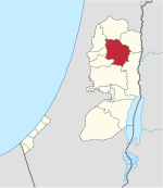
| Governacions | Governació de Nablus  | |||
| Població humana | ||||
| Població | 13.477 (2017) (0,47 hab./km²) | |||
| Geografia | ||||
| Superfície | 28.550 dúnams | |||
| Altitud | 417 m | |||
| Identificador descriptiu | ||||
| Codi postal | 470 | |||
| Fus horari | UTC+02:00, hora estàndard UTC+03:00, horari d'estiu | |||


Beit Furik (àrab: بيت فوريك, Bayt Fūrīk) és un municipi palestí de la governació de Nablus, a Cisjordània, al nord de la vall del Jordà, 9 kilòmetres al sud-est de Nablus. Segons l'Oficina Central Palestina d'Estadístiques tenia 10.339 habitants en 2007.[1] Durant el segle xix i meitat del segle XX Beit Furik fou el principal proveïdor de calç per a la fabricació del sabó de Nabulsi a Nablus.[2]
Referències
- ↑ 2007 PCBS Census Arxivat 2019-04-09 a Wayback Machine.. Palestinian Central Bureau of Statistics. p.110.
- ↑ Soap, Class, and State (1995) Doumani, Beshara. University of California.
Bibliografia
- Barron, J. B.. Palestine: Report and General Abstracts of the Census of 1922. Government of Palestine, 1923.
- Conder, Claude Reignier; Kitchener, H.H.. The Survey of Western Palestine: Memoirs of the Topography, Orography, Hydrography, and Archaeology. 2. Londres: Committee of the Palestine Exploration Fund, 1882. (p. 229)
- Conder, C. R. «Norman Palestine». Quarterly statement - Palestine Exploration Fund, 22, 1890, pàg. 29–37. (p. 32)
- Dauphin, Claudine. La Palestine byzantine, Peuplement et Populations (en francès). III : Catalogue. Oxford: Archeopress, 1998. (p. 848)
- Finkelstein, I.; Lederman, Zvi. Highlands of many cultures. Tel Aviv: Institute of Archaeology of Tel Aviv University Publications Section, 1997. ISBN 965-440-007-3. (II p. 814)
- Guérin, V. Description Géographique Historique et Archéologique de la Palestine (en francès). 2: Samarie, pt. 1. París: L'Imprimerie Nationale, 1874. (p. 455)
- Hadawi, S. Village Statistics of 1945: A Classification of Land and Area ownership in Palestine. Palestine Liberation Organization Research Center, 1970.
- Hütteroth, Wolf-Dieter; Abdulfattah, Kamal. Historical Geography of Palestine, Transjordan and Southern Syria in the Late 16th Century. Erlanger Geographische Arbeiten, Sonderband 5. Erlangen, Germany: Vorstand der Fränkischen Geographischen Gesellschaft, 1977. ISBN 3-920405-41-2. (p. 132)
- Mills, E.. Census of Palestine 1931. Population of Villages, Towns and Administrative Areas. Jerusalem: Government of Palestine, 1932.
- Palmer, E. H.. The Survey of Western Palestine: Arabic and English Name Lists Collected During the Survey by Lieutenants Conder and Kitchener, R. E. Transliterated and Explained by E.H. Palmer. Committee of the Palestine Exploration Fund, 1881. (p. 199)
- Robinson, E.; Smith, E. Biblical Researches in Palestine, Mount Sinai and Arabia Petraea: A Journal of Travels in the year 1838. 3. Boston: Crocker & Brewster, 1841. (p. 102)
- Röhricht, R. «Studien zur mittelalterlichen Geographie und Topographie Syriens». Zeitschrift des Deutschen Palästina-Vereins, 10, 1887, pàg. 195–344. (p. 205)
- Röhricht, Reinhold. (RRH) Regesta regni Hierosolymitani (MXCVII-MCCXCI) (en llatí). Berlín: Libraria Academica Wageriana, 1893. (p. 30, no. 121)
| Ciutats |
|  |
|---|---|---|
| Municipis |
| |
| Viles |
| |
| Camps de refugiats | ||

